IMAGES TAKEN NEAR TO
Three Waters Walk, LONDON, E3 3YN
Introduction
This page details the photographs taken nearby to Three Waters Walk, E3 3YN by members of the Geograph project.
The Geograph project started in 2005 with the aim of publishing, organising and preserving representative images for every square kilometre of Great Britain, Ireland and the Isle of Man.

There are currently over 7.5m images from over14,400 individuals and you can help contribute to the project by visiting https://www.geograph.org.uk
Image Map (Loading...)


Getting Data...Please wait
Leaflet Map data © OpenStreetMap
Images are licensed for reuse under creativecommons.org/licenses/by-sa/2.0
Notes
- Clicking on the map will re-center to the selected point.
- The higher the marker number, the further away the image location is from the centre of the postcode.
Image Listing (122 Images Found)
Images are licensed for reuse under creativecommons.org/licenses/by-sa/2.0
Image
Details
Distance
1
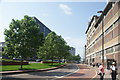
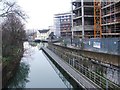
View of new apartments on Gillender Street from Navigation Road
Looking south-southwest.
Image: © Robert Lamb
Taken: 5 Jun 2016
0.02 miles
2
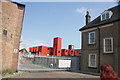
View of a container city in the Veolia offices on Gillender Street
Looking north-northeast.
Image: © Robert Lamb
Taken: 5 Jun 2016
0.03 miles
3
View back up Gillender Street
Looking north back towards Stratford.
Image: © Robert Lamb
Taken: 5 Jun 2016
0.04 miles
4
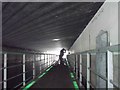
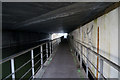
Floating towpath carried under the dual carriageway
The authorities have been very thoughtful in adding illumination to the path as it is carried under the roadway.
Image: © John Reeves
Taken: 27 Jan 2010
0.04 miles
7
Limehouse Cut - floating towpath
Looking south towards the bridge carrying the Blackwall Tunnel Northern Approach and Gillender Street. There was no towpath under, and a very lengthy floating towpath has been installed.
Image: © Robin Webster
Taken: 11 Dec 2010
0.04 miles
8
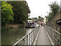
Walkway on the Limehouse Cut
A recent addition, a walkway over the water to allow people to walk along the canal where there is no formal towpath.
Image: © Stephen Craven
Taken: 15 Jun 2014
0.05 miles
9
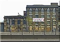
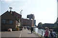
Nineteenth century warehouse, with ghost sign, Bromley-by-Bow
Grade II listed building, known as Dowgate Wharf of P.B. Burgoyne, and later Aplin's Distillery (hence the lettering on the facade). A rare survivor.
Image: © Jim Osley
Taken: 24 Apr 2015
0.05 miles
10
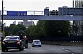
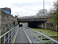
Blackwall Tunnel Northern Approach (A12)
Image: © Steve Daniels
Taken: 1 Oct 2022
0.05 miles