IMAGES TAKEN NEAR TO
Culvert Drive, LONDON, E3 3UG
Introduction
This page details the photographs taken nearby to Culvert Drive, E3 3UG by members of the Geograph project.
The Geograph project started in 2005 with the aim of publishing, organising and preserving representative images for every square kilometre of Great Britain, Ireland and the Isle of Man.

There are currently over 7.5m images from over14,400 individuals and you can help contribute to the project by visiting https://www.geograph.org.uk
Image Map (Loading...)


Getting Data...Please wait
Leaflet Map data © OpenStreetMap
Images are licensed for reuse under creativecommons.org/licenses/by-sa/2.0
Notes
- Clicking on the map will re-center to the selected point.
- The higher the marker number, the further away the image location is from the centre of the postcode.
Image Listing (270 Images Found)
Images are licensed for reuse under creativecommons.org/licenses/by-sa/2.0
Image
Details
Distance
1

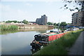
'The Grass is always Greener'
A statement on the east bank of the River Lee Navigation.
Image: © Robin Webster
Taken: 11 Dec 2010
0.04 miles
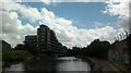
2
View of flats on the River Lea from the River Lea Navigation
Looking south-southeast.
Image: © Robert Lamb
Taken: 5 Jun 2016
0.05 miles
3
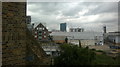
View of the Arcelo-Mittal Orbit sculpture and flats on Stratford High Street from the third floor of the House Mill #2
Looking north-northwest.
Image: © Robert Lamb
Taken: 25 Jul 2013
0.05 miles
4
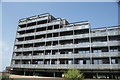
View of apartments on the River Lea from the River Lea towpath #3
Looking north-northeast.
Image: © Robert Lamb
Taken: 5 Jun 2016
0.05 miles
5
River Lee Navigation
Looking upstream.
Image: © Robin Webster
Taken: 11 Dec 2010
0.05 miles
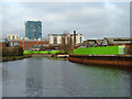
6
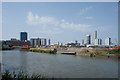
View of derelict industrial land and the Olympic Park from the River Lea Navigation
Looking north-northwest.
Image: © Robert Lamb
Taken: 5 Jun 2016
0.06 miles
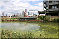
7
View of new flats on the Lea Navigation
Looking south-southeast.
Image: © Robert Lamb
Taken: 25 Jul 2013
0.06 miles
8
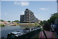
View of flats on the River Lea from the River Lea Navigation #2
Looking south-southeast.
Image: © Robert Lamb
Taken: 5 Jun 2016
0.06 miles
9
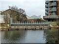
Former entrance to watercourse near Three Mills, London E15
Crossing the centre of the image is the blocked-off entry to a short watercourse that linked the River Lea (or Lee) in the foreground with Three Mills Wall River which is to be found on the far side of the building on the right just outside the picture. See Image
Image: © David Kemp
Taken: 5 Jul 2016
0.06 miles
10
Weir, River Lee Navigation
So mapped, but it looks more of a dam, with tidal waters beyond.
Image: © Robin Webster
Taken: 11 Dec 2010
0.06 miles