IMAGES TAKEN NEAR TO
Guy Townsley Square, LONDON, E3 3TX
Introduction
This page details the photographs taken nearby to Guy Townsley Square, E3 3TX by members of the Geograph project.
The Geograph project started in 2005 with the aim of publishing, organising and preserving representative images for every square kilometre of Great Britain, Ireland and the Isle of Man.

There are currently over 7.5m images from over14,400 individuals and you can help contribute to the project by visiting https://www.geograph.org.uk
Image Map
Images are licensed for reuse under creativecommons.org/licenses/by-sa/2.0
Notes
- Clicking on the map will re-center to the selected point.
- The higher the marker number, the further away the image location is from the centre of the postcode.
Image Listing (97 Images Found)
Images are licensed for reuse under creativecommons.org/licenses/by-sa/2.0
Image
Details
Distance
1

Part of the Old Devons Road locomotive depot
London Docklands railway now passes the site which has been obliterated
Image: © John Firth
Taken: Unknown
0.05 miles

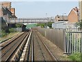
3

Devons Road station
Heading towards Poplar on the Docklands Light Railway. Here the route uses the formation of the old North London Railway.
Image: © Robin Webster
Taken: 29 Jan 2011
0.09 miles
4
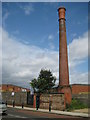
Bromley-by-Bow: Violet Road sewer ventilation shaft
This solitary brick-built structure, that looks like a former factory chimney, is on the east side of Violet Road, and is in fact a sewer ventilation shaft, probably dating back to late Victorian times. It serves the same function as the familiar but smaller vertical iron pipe type vents that are used on ordinary residential sewers, but must be connected to one of London's main outfall sewers to justify its size.
Image: © Nigel Cox
Taken: 19 Aug 2008
0.09 miles
5
Docklands Light Railway north of Langdon Park station
Image: © Peter Whatley
Taken: 11 Apr 2011
0.09 miles
6
Docklands Light Railway train crossing the Limehouse Cut
Image: © David Martin
Taken: 6 Aug 2013
0.09 miles
7
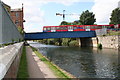
Docklands Light Railway bridge over Limehouse Cut
Looking southwest.
Image: © Dr Neil Clifton
Taken: 3 Sep 2008
0.09 miles
8
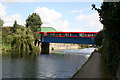
Docklands Light Railway bridge over Limehouse Cut
Looking northeast. The DLR train crossing is composed of the latest type of stock, introduced in 2008. This part of the DLR follows the course of a former line opened by the North London Railway in 1850 and connecting with the London & Blackwall by a west-facing junction at Stepney, and later an east-facing junction at Limehouse.
Image: © Dr Neil Clifton
Taken: 3 Sep 2008
0.10 miles
9
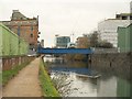
Docklands Light Railway bridge over Limehouse Cut
Building development is changing the character of the scene in Image, as apartments go up on the Strong and Hoe site between the DLR bridge and Violet Road.
Image: © Derek Harper
Taken: 12 Jan 2011
0.10 miles
10
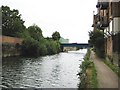
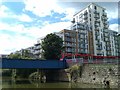
Limehouse Cut (2)
The Limehouse Cut was built to provide a navigable short-cut from the River Thames at Limehouse Basin north-east to the River Lee Navigation at Bromley-by-Bow, thus avoiding the long meandering curves of the lower reaches of the River Lee at Bow Creek, and the long bend in the River Thames around the Isle of Dogs. It was authorised by the River Lee Act of 1766, and completed in 1770 so it is effectively the oldest canal in London. This view was taken from under the Morris Road bridge looking in the direction of Bromley-by-Bow.
The blue bridge in the distance carries the Docklands Light Railway over the cut.
The towpath on the right forms a section of the Lea Valley Walk. It is also shown on the Ordnance Survey 1:25,000 scale maps as a series of solid light brown circles, indicating an off road cycle route.
Image: © Nigel Cox
Taken: 19 Aug 2008
0.10 miles