IMAGES TAKEN NEAR TO
Yeo Street, LONDON, E3 3NU
Introduction
This page details the photographs taken nearby to Yeo Street, E3 3NU by members of the Geograph project.
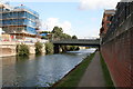
The Geograph project started in 2005 with the aim of publishing, organising and preserving representative images for every square kilometre of Great Britain, Ireland and the Isle of Man.

There are currently over 7.5m images from over14,400 individuals and you can help contribute to the project by visiting https://www.geograph.org.uk
Image Map (Loading...)


Getting Data...Please wait
Leaflet Map data © OpenStreetMap
Images are licensed for reuse under creativecommons.org/licenses/by-sa/2.0
Notes
- Clicking on the map will re-center to the selected point.
- The higher the marker number, the further away the image location is from the centre of the postcode.
Image Listing (98 Images Found)
Images are licensed for reuse under creativecommons.org/licenses/by-sa/2.0
Image
Details
Distance
1
Canal bridge, coat of arms
Coat of arms on the bridge over the Limehouse Cut.
Image: © Malc McDonald
Taken: 1 May 2010
0.04 miles
2
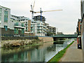
Limehouse Cut, Morris Road bridge
A lot of building work had been done or was in hand along the cut.
Image: © Robin Webster
Taken: 11 Dec 2010
0.06 miles
3
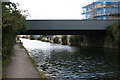
Violet Road bridge over Limehouse Cut
Looking southwest.
Image: © Dr Neil Clifton
Taken: 3 Sep 2008
0.06 miles
4
Morris Road bridge
The bridge, opened in 1890, crosses the Limehouse Cut canal.
Image: © Stephen Craven
Taken: 15 Jun 2014
0.06 miles
5
Violet Road bridge over Limehouse Cut
Looking northeast. Violet Road is a minor urban road, much used by 'rat runners'
Image: © Dr Neil Clifton
Taken: 3 Sep 2008
0.06 miles
6
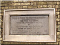
Morris Road bridge: datestone
The stone plaque records the opening of the bridge on 19 May 1890, "for the use of the public for ever". See Image for context.
Image: © Stephen Craven
Taken: 15 Jun 2014
0.07 miles
7
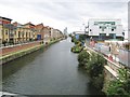
Limehouse Cut (1)
The Limehouse Cut was built to provide a navigable short-cut from the River Thames at Limehouse Basin north-east to the River Lee Navigation at Bromley-by-Bow, thus avoiding the long meandering curves of the lower reaches of the River Lee at Bow Creek, and the long bend in the River Thames around the Isle of Dogs. It was authorised by the River Lee Act of 1766, and completed in 1770 so it is effectively the oldest canal in London. This view was taken from the Morris Road bridge looking in the direction of Limehouse.
The towpath on the left forms a section of the Lea Valley Walk. It is also shown on the Ordnance Survey 1:25,000 scale maps as a series of solid light brown circles, indicating an off road cycle route.
Image: © Nigel Cox
Taken: 19 Aug 2008
0.07 miles
8

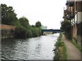
Limehouse Cut
Looking west from Violet Road bridge
Image: © Malc McDonald
Taken: 1 May 2010
0.07 miles
9
Limehouse Cut (2)
The Limehouse Cut was built to provide a navigable short-cut from the River Thames at Limehouse Basin north-east to the River Lee Navigation at Bromley-by-Bow, thus avoiding the long meandering curves of the lower reaches of the River Lee at Bow Creek, and the long bend in the River Thames around the Isle of Dogs. It was authorised by the River Lee Act of 1766, and completed in 1770 so it is effectively the oldest canal in London. This view was taken from under the Morris Road bridge looking in the direction of Bromley-by-Bow.
The blue bridge in the distance carries the Docklands Light Railway over the cut.
The towpath on the right forms a section of the Lea Valley Walk. It is also shown on the Ordnance Survey 1:25,000 scale maps as a series of solid light brown circles, indicating an off road cycle route.
Image: © Nigel Cox
Taken: 19 Aug 2008
0.07 miles
10
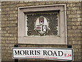
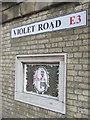
Morris Road bridge: carved plaque
The stone plaque on Morris Road bridge Image is intriguing as it appears to illustrate a bishop, but no bishop is named on the opening plaque Image
Image: © Stephen Craven
Taken: 15 Jun 2014
0.07 miles