1
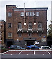
Kingsley Hall
Situated on Powis Road near to its junction with Bruce Road. The blue plaque commemorates Ghandi's visit in 1931.
Blue plaque: http://www.geograph.org.uk/photo/996919
Image: © Peter Thwaite
Taken: 1 Oct 2008
0.06 miles
2
Kingsley Hall Community Centre
Built 1927 to the designs of architect Charles Cowles-Voysey (1889-1981). For more on the history of Kingsley Hall and its radical associations see this http://en.wikipedia.org/wiki/Kingsley_Ha. Grade II listed building described at this http://list.english-heritage.org.uk/resultsingle.aspx?uid=1357884.
Image: © Jim Osley
Taken: 29 Nov 2013
0.06 miles
3
Denbury House
Image: © N Chadwick
Taken: 14 Jun 2014
0.07 miles
4
William Guy Gardens
Sports pitch in William Guy Gardens. Bromley-by-Bow station platforms are behind it.
Image: © Malc McDonald
Taken: 1 May 2010
0.07 miles
5
Kingsley Hall
The London County Council's blue plaque on Kinsley Hall commemorates Ghandi's stay in 1931 for the conference on the future governance on the Indian Empire.
see http://www.geograph.org.uk/photo/996918
Image: © Peter Thwaite
Taken: 1 Oct 2008
0.07 miles
6
Devons Road bridge
Railway bridge over Devons Road, carrying London Underground and national rail services.
Image: © Malc McDonald
Taken: 1 May 2010
0.09 miles
7
Bromley (by-Bow) Station
View eastward, towards Barking and Upminster on LTE electric lines, also towards Tilbury and Southend on ex-London, Tilbury & Southend main line from Fenchurch Street (on right). Only a few main-line trains called at Bromley after 27/10/40 and they ceased to do so after electrification in 1962. The station was renamed 'Bromley-by-Bow' in 1967 and was transferred from BR to the LTB on 1/1/69.
Image: © Ben Brooksbank
Taken: 12 May 1961
0.10 miles
8
Bromley-by-Bow tube station, Greater London
Opened in 1858 as Bromley by the London Tilbury & Southend Railway on the line from London to Upminster, this station was rebuilt in 1905 when the District Line platforms to the left were added, and again in 1972 following a fire. 'Heavy rail' trains ceased to call at the platforms on the right in 1962 and the station was transferred from British Rail to London Transport in 1969. It was renamed Bromley-by-Bow in 1967.
View east towards West Ham and Upminster.
Image: © Nigel Thompson
Taken: 24 Sep 2015
0.10 miles
9
Bromley-by-Bow station
A westbound Hammersmith and City train is just leaving.
Image: © Dr Neil Clifton
Taken: 18 Sep 2008
0.11 miles
10
Bromley by Bow: Arrow Road, E3
A lot of the Victorian housing stock in this area has been lost but there are odd groupings that survive. This terrace is on the south side of the road, but note the modern terrace further down, where the architect has attempted, not very successfully, to replicate the design of the older houses. If you look at the aerial photography, with the birds eye view looking at the rear of the terrace, on http://maps.live.com the difference between the two terraces is quite startling. The older ones have individual pitched roofs behind the front parapet wall while the newer ones have one continuous pitched roof with the ridge line parallel to the road. The older ones have individual rear extensions while the new ones have no extensions at all.
Up to and including the edition of 1899 the Ordnance Survey mapping of this area clearly shows this street as Orwell Road. However by 1920 the OS have the current name of Arrow Road. Quite why Orwell fell out of favour is a mystery.
Image: © Nigel Cox
Taken: 15 Apr 2008
0.11 miles


