IMAGES TAKEN NEAR TO
Powis Road, LONDON, E3 3HJ
Introduction
This page details the photographs taken nearby to Powis Road, E3 3HJ by members of the Geograph project.
The Geograph project started in 2005 with the aim of publishing, organising and preserving representative images for every square kilometre of Great Britain, Ireland and the Isle of Man.

There are currently over 7.5m images from over14,400 individuals and you can help contribute to the project by visiting https://www.geograph.org.uk
Image Map (Loading...)


Getting Data...Please wait
Leaflet Map data © OpenStreetMap
Images are licensed for reuse under creativecommons.org/licenses/by-sa/2.0
Notes
- Clicking on the map will re-center to the selected point.
- The higher the marker number, the further away the image location is from the centre of the postcode.
Image Listing (202 Images Found)
Images are licensed for reuse under creativecommons.org/licenses/by-sa/2.0
Image
Details
Distance
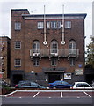
1
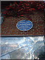
Kingsley Hall
The London County Council's blue plaque on Kinsley Hall commemorates Ghandi's stay in 1931 for the conference on the future governance on the Indian Empire.
see http://www.geograph.org.uk/photo/996918
Image: © Peter Thwaite
Taken: 1 Oct 2008
0.01 miles
2
Kingsley Hall
Situated on Powis Road near to its junction with Bruce Road. The blue plaque commemorates Ghandi's visit in 1931.
Blue plaque: http://www.geograph.org.uk/photo/996919
Image: © Peter Thwaite
Taken: 1 Oct 2008
0.02 miles
3
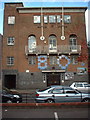
Kingsley Hall Community Centre
Built 1927 to the designs of architect Charles Cowles-Voysey (1889-1981). For more on the history of Kingsley Hall and its radical associations see this http://en.wikipedia.org/wiki/Kingsley_Ha. Grade II listed building described at this http://list.english-heritage.org.uk/resultsingle.aspx?uid=1357884.
Image: © Jim Osley
Taken: 29 Nov 2013
0.03 miles
5
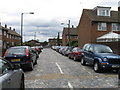
Crossing the Street
Pretty much the same location as Image which is in bright colour and has a full description.
I just put in this b&w shot cos I quite like it.
Image: © Des Blenkinsopp
Taken: 10 Mar 2011
0.09 miles
6
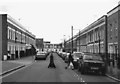
Franklin Street, Bromley
A cobbled street
Image: © Alex McGregor
Taken: 26 Jul 2010
0.09 miles
7
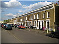
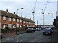
Bromley by Bow: Arrow Road, E3
A lot of the Victorian housing stock in this area has been lost but there are odd groupings that survive. This terrace is on the south side of the road, but note the modern terrace further down, where the architect has attempted, not very successfully, to replicate the design of the older houses. If you look at the aerial photography, with the birds eye view looking at the rear of the terrace, on http://maps.live.com the difference between the two terraces is quite startling. The older ones have individual pitched roofs behind the front parapet wall while the newer ones have one continuous pitched roof with the ridge line parallel to the road. The older ones have individual rear extensions while the new ones have no extensions at all.
Up to and including the edition of 1899 the Ordnance Survey mapping of this area clearly shows this street as Orwell Road. However by 1920 the OS have the current name of Arrow Road. Quite why Orwell fell out of favour is a mystery.
Image: © Nigel Cox
Taken: 15 Apr 2008
0.09 miles
8
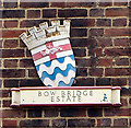
Shield plaque, Bow Bridge Estate
A reminder of the work of the London Council Council in providing council housing in the 1930s.
Image: © Jim Osley
Taken: 29 Nov 2013
0.09 miles
10

A Green Lung
Hard to believe, sandwiched between Bromley High Street and the Blackwall Tunnel Approach Road, is this peaceful oasis of green in the concrete jungle of East London.
Image: © Dr Duncan Pepper
Taken: 22 Nov 2009
0.09 miles