IMAGES TAKEN NEAR TO
Harston Walk, LONDON, E3 3GP
Introduction
This page details the photographs taken nearby to Harston Walk, E3 3GP by members of the Geograph project.
The Geograph project started in 2005 with the aim of publishing, organising and preserving representative images for every square kilometre of Great Britain, Ireland and the Isle of Man.

There are currently over 7.5m images from over14,400 individuals and you can help contribute to the project by visiting https://www.geograph.org.uk
Image Map (Loading...)


Getting Data...Please wait
Leaflet Map data © OpenStreetMap
Images are licensed for reuse under creativecommons.org/licenses/by-sa/2.0
Notes
- Clicking on the map will re-center to the selected point.
- The higher the marker number, the further away the image location is from the centre of the postcode.
Image Listing (155 Images Found)
Images are licensed for reuse under creativecommons.org/licenses/by-sa/2.0
Image
Details
Distance
4
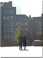
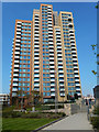
Jefferson Plaza, Bromley
A couple stroll across Jefferson Plaza adjacent to Bromley by Bow Underground Station. One Canada Square at Canary Wharf can just be seen in the hazy sunshine.
Image: © Stephen McKay
Taken: 2 Oct 2015
0.05 miles
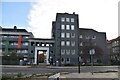
5
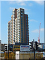
Marner Point
27-story block adjacent to Bromley by Bow Underground station.
Image: © Stephen McKay
Taken: 2 Oct 2015
0.05 miles
7
Marner Point from Twelvetrees Crescent, Bromley
An unlovely corner of east London: in the foreground a number of makeshift businesses occupy land created in the loop of Twelvetrees Crescent, beyond that is the 27-storey Marner Point.
Image: © Stephen McKay
Taken: 2 Oct 2015
0.06 miles
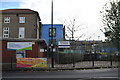
9
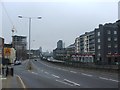
Blackwall Tunnel Northern Approach, Bromley-by-Bow
Image: © Chris Whippet
Taken: 4 Jan 2015
0.07 miles
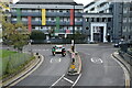
10
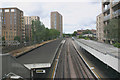
Bromley-by-Bow Underground station
Taken looking westbound. On the left one of the two former London, Tilbury & Southend (LTS) platforms can be seen. Trains ceased to call at these platforms when the LTS was electrified in 1962.
Image: © David Kemp
Taken: 5 Jul 2016
0.07 miles