IMAGES TAKEN NEAR TO
Bromley High Street, LONDON, E3 3EH
Introduction
This page details the photographs taken nearby to Bromley High Street, E3 3EH by members of the Geograph project.
The Geograph project started in 2005 with the aim of publishing, organising and preserving representative images for every square kilometre of Great Britain, Ireland and the Isle of Man.

There are currently over 7.5m images from over14,400 individuals and you can help contribute to the project by visiting https://www.geograph.org.uk
Image Map
Images are licensed for reuse under creativecommons.org/licenses/by-sa/2.0
Notes
- Clicking on the map will re-center to the selected point.
- The higher the marker number, the further away the image location is from the centre of the postcode.
Image Listing (215 Images Found)
Images are licensed for reuse under creativecommons.org/licenses/by-sa/2.0
Image
Details
Distance
3
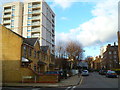
Looking north on Edgar Road from the junction with Arrow Road
Image: © Shazz
Taken: 9 Jan 2014
0.02 miles
4
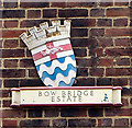
Shield plaque, Bow Bridge Estate
A reminder of the work of the London Council Council in providing council housing in the 1930s.
Image: © Jim Osley
Taken: 29 Nov 2013
0.03 miles
5
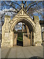
Bromley by Bow: How Memorial Gateway
This fine arched entrance and a few old gravestones are all that is left of the former church of Bromley St Leonard, which was destroyed by bombing during the Second World War. The gateway, which led into the churchyard, is in remembrance of the Reverend George Augustus Mayo How (1840 - 1893), vicar of the parish for twenty years. The churchyard beyond is now a Playspace.
The Gateway is listed in English Heritage's Buildings at Risk register of 2008, where its condition is described as poor. From the list it is described as a gable stoned gothic arch with double buttresses at each side.
Image: © Nigel Cox
Taken: 15 Apr 2008
0.04 miles
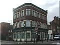
6
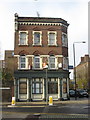
Former Public House at the corner of Bromley High Street
Now just rather forlornly, flats to rent.
Image: © Dr Duncan Pepper
Taken: 22 Nov 2009
0.05 miles
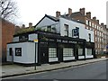
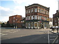
7

Bromley by Bow: Blue Anchor public house
The pub is on Bromley High Street at its junction with Edgar Road (in the foreground).
Image: © Nigel Cox
Taken: 15 Apr 2008
0.05 miles
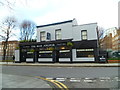
8
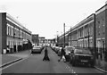
Crossing the Street
Pretty much the same location as Image which is in bright colour and has a full description.
I just put in this b&w shot cos I quite like it.
Image: © Des Blenkinsopp
Taken: 10 Mar 2011
0.06 miles
9
Bromley by Bow: Former Pearly King public house
Now converted to flats this is the former Pearly King public house on Bromley High Street (to the right) at its junction with St Leonard's Street (to the left). It was previously known as the Seven Stars.
Image: © Nigel Cox
Taken: 15 Apr 2008
0.06 miles