IMAGES TAKEN NEAR TO
Bromley High Street, LONDON, E3 3EG
Introduction
This page details the photographs taken nearby to Bromley High Street, E3 3EG by members of the Geograph project.
The Geograph project started in 2005 with the aim of publishing, organising and preserving representative images for every square kilometre of Great Britain, Ireland and the Isle of Man.

There are currently over 7.5m images from over14,400 individuals and you can help contribute to the project by visiting https://www.geograph.org.uk
Image Map (215 Images)


Leaflet Map data © OpenStreetMap
Images are licensed for reuse under creativecommons.org/licenses/by-sa/2.0
Notes
- Clicking on the map will re-center to the selected point.
- The higher the marker number, the further away the image location is from the centre of the postcode.
Image Listing (215 Images Found)
Images are licensed for reuse under creativecommons.org/licenses/by-sa/2.0
Image
Details
Distance
1
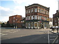
Bromley by Bow: Former Pearly King public house
Now converted to flats this is the former Pearly King public house on Bromley High Street (to the right) at its junction with St Leonard's Street (to the left). It was previously known as the Seven Stars.
Image: © Nigel Cox
Taken: 15 Apr 2008
0.00 miles
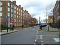
3
St Leonard's Adventure Playground
Entrance to St Leonard's Adventure Playground.
Image: © Malc McDonald
Taken: 1 May 2010
0.01 miles
4
St Leonard's Adventurous Playspace (S.L.A.P.)
Well I think the sign board says it all, sadly there were no adventurers in this urban jungle.
Image: © Dr Duncan Pepper
Taken: 22 Nov 2009
0.01 miles
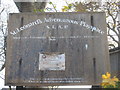
5
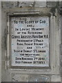
Memorial Plaque
Set in the ornamental archway that is all that remains of this cemetery in Bromley High Street.
Image: © Dr Duncan Pepper
Taken: 22 Nov 2009
0.01 miles
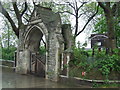
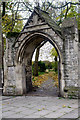
7
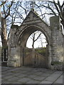
The How Memorial Gateway
A rather "over the top" memorial to a past reverend, and now leading into a former cemetery gently decaying into a nature reserve.
Image: © Dr Duncan Pepper
Taken: 22 Nov 2009
0.02 miles
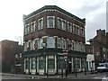
8
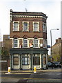
Former Public House at the corner of Bromley High Street
Now just rather forlornly, flats to rent.
Image: © Dr Duncan Pepper
Taken: 22 Nov 2009
0.02 miles
9
How Memorial Gateway, Bromley-by-Bow
Grade II listed structure, at the entrance to the site of the former St Leonard's Priory and the church of Bromley-St-Leonard (destroyed by bombing and the later construction of the Blackwall Tunnel northern approach road).
Image: © Jim Osley
Taken: 29 Nov 2013
0.02 miles
10

A Green Lung
Hard to believe, sandwiched between Bromley High Street and the Blackwall Tunnel Approach Road, is this peaceful oasis of green in the concrete jungle of East London.
Image: © Dr Duncan Pepper
Taken: 22 Nov 2009
0.03 miles