IMAGES TAKEN NEAR TO
Patrick Connolly Gardens, LONDON, E3 3BY
Introduction
This page details the photographs taken nearby to Patrick Connolly Gardens, E3 3BY by members of the Geograph project.
The Geograph project started in 2005 with the aim of publishing, organising and preserving representative images for every square kilometre of Great Britain, Ireland and the Isle of Man.

There are currently over 7.5m images from over14,400 individuals and you can help contribute to the project by visiting https://www.geograph.org.uk
Image Map
Images are licensed for reuse under creativecommons.org/licenses/by-sa/2.0
Notes
- Clicking on the map will re-center to the selected point.
- The higher the marker number, the further away the image location is from the centre of the postcode.
Image Listing (131 Images Found)
Images are licensed for reuse under creativecommons.org/licenses/by-sa/2.0
Image
Details
Distance
1
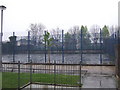
William Guy Gardens
Sports pitch in William Guy Gardens. Bromley-by-Bow station platforms are behind it.
Image: © Malc McDonald
Taken: 1 May 2010
0.05 miles
2
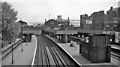
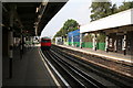
Bromley (by-Bow) Station
View eastward, towards Barking and Upminster on LTE electric lines, also towards Tilbury and Southend on ex-London, Tilbury & Southend main line from Fenchurch Street (on right). Only a few main-line trains called at Bromley after 27/10/40 and they ceased to do so after electrification in 1962. The station was renamed 'Bromley-by-Bow' in 1967 and was transferred from BR to the LTB on 1/1/69.
Image: © Ben Brooksbank
Taken: 12 May 1961
0.07 miles
3
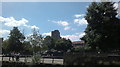
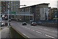
View of the new towerblock on the A12 and the back of Tesco from the road outside the House Mill
Looking south-southwest.
Image: © Robert Lamb
Taken: 24 Jul 2013
0.08 miles
6
Bromley-by-Bow station
A westbound Hammersmith and City train is just leaving.
Image: © Dr Neil Clifton
Taken: 18 Sep 2008
0.08 miles
7
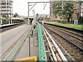
Bromley-by-Bow tube station, Greater London
Opened in 1858 as Bromley by the London Tilbury & Southend Railway on the line from London to Upminster, this station was rebuilt in 1905 when the District Line platforms to the left were added, and again in 1972 following a fire. 'Heavy rail' trains ceased to call at the platforms on the right in 1962 and the station was transferred from British Rail to London Transport in 1969. It was renamed Bromley-by-Bow in 1967.
View east towards West Ham and Upminster.
Image: © Nigel Thompson
Taken: 24 Sep 2015
0.08 miles
8
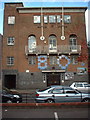
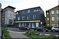
Kingsley Hall
Situated on Powis Road near to its junction with Bruce Road. The blue plaque commemorates Ghandi's visit in 1931.
Blue plaque: http://www.geograph.org.uk/photo/996919
Image: © Peter Thwaite
Taken: 1 Oct 2008
0.08 miles
10
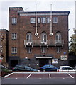
Kingsley Hall Community Centre
Built 1927 to the designs of architect Charles Cowles-Voysey (1889-1981). For more on the history of Kingsley Hall and its radical associations see this http://en.wikipedia.org/wiki/Kingsley_Ha. Grade II listed building described at this http://list.english-heritage.org.uk/resultsingle.aspx?uid=1357884.
Image: © Jim Osley
Taken: 29 Nov 2013
0.08 miles