IMAGES TAKEN NEAR TO
St. Leonards Street, LONDON, E3 3BT
Introduction
This page details the photographs taken nearby to St. Leonards Street, E3 3BT by members of the Geograph project.
The Geograph project started in 2005 with the aim of publishing, organising and preserving representative images for every square kilometre of Great Britain, Ireland and the Isle of Man.

There are currently over 7.5m images from over14,400 individuals and you can help contribute to the project by visiting https://www.geograph.org.uk
Image Map (Loading...)


Getting Data...Please wait
Leaflet Map data © OpenStreetMap
Images are licensed for reuse under creativecommons.org/licenses/by-sa/2.0
Notes
- Clicking on the map will re-center to the selected point.
- The higher the marker number, the further away the image location is from the centre of the postcode.
Image Listing (271 Images Found)
Images are licensed for reuse under creativecommons.org/licenses/by-sa/2.0
Image
Details
Distance
2
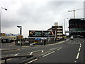
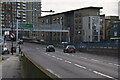
View of the new towerblock on the A12 and the back of Tesco from the road outside the House Mill
Looking south-southwest.
Image: © Robert Lamb
Taken: 24 Jul 2013
0.07 miles
4
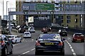
The Blackwall Tunnel Northern Approach (A12)
Image: © Steve Daniels
Taken: 1 Oct 2022
0.07 miles
6
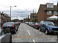
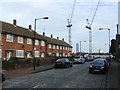
Franklin Street, Bromley
A cobbled street
Image: © Alex McGregor
Taken: 26 Jul 2010
0.08 miles
9
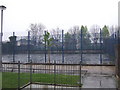
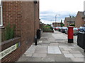
William Guy Gardens
Sports pitch in William Guy Gardens. Bromley-by-Bow station platforms are behind it.
Image: © Malc McDonald
Taken: 1 May 2010
0.10 miles
10
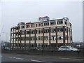
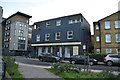
Derelict Brown & Tawse Office Building, Bromley-by-Bow
Image: © Chris Whippet
Taken: 4 Jan 2015
0.10 miles