IMAGES TAKEN NEAR TO
Wick Lane, LONDON, E3 2PW
Introduction
This page details the photographs taken nearby to Wick Lane, E3 2PW by members of the Geograph project.
The Geograph project started in 2005 with the aim of publishing, organising and preserving representative images for every square kilometre of Great Britain, Ireland and the Isle of Man.

There are currently over 7.5m images from over14,400 individuals and you can help contribute to the project by visiting https://www.geograph.org.uk
Image Map
Images are licensed for reuse under creativecommons.org/licenses/by-sa/2.0
Notes
- Clicking on the map will re-center to the selected point.
- The higher the marker number, the further away the image location is from the centre of the postcode.
Image Listing (335 Images Found)
Images are licensed for reuse under creativecommons.org/licenses/by-sa/2.0
Image
Details
Distance
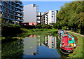
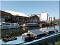
1
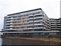
Wick Lane Wharf, Hackney Wick
This is a large block of river-side apartments, as seen from the path beside the River Lee Navigational Cut.
Image: © David Anstiss
Taken: 31 Mar 2013
0.01 miles
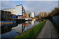
3
View of apartments on the River Lea from the River Lea towpath #2
Looking north-northwest.
Image: © Robert Lamb
Taken: 5 Jun 2016
0.02 miles
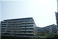
4
View of apartments on the River Lea from the River Lea towpath
Looking north-northwest.
Image: © Robert Lamb
Taken: 5 Jun 2016
0.02 miles
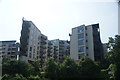
5
View of boats and graffiti on the River Lea
Looking northwest.
Image: © Robert Lamb
Taken: 4 Apr 2021
0.02 miles