IMAGES TAKEN NEAR TO
Wick Lane, LONDON, E3 2JJ
Introduction
This page details the photographs taken nearby to Wick Lane, E3 2JJ by members of the Geograph project.
The Geograph project started in 2005 with the aim of publishing, organising and preserving representative images for every square kilometre of Great Britain, Ireland and the Isle of Man.

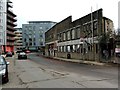
There are currently over 7.5m images from over14,400 individuals and you can help contribute to the project by visiting https://www.geograph.org.uk
Image Map
Images are licensed for reuse under creativecommons.org/licenses/by-sa/2.0
Notes
- Clicking on the map will re-center to the selected point.
- The higher the marker number, the further away the image location is from the centre of the postcode.
Image Listing (323 Images Found)
Images are licensed for reuse under creativecommons.org/licenses/by-sa/2.0
Image
Details
Distance
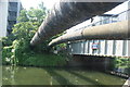
2
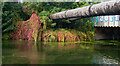
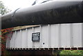
Lee Navigation: Pipe bridge and Northern Outfall Sewer
The Sewer carries a footpath and cycleway
Image: © Dr Neil Clifton
Taken: 18 Sep 2008
0.02 miles
5
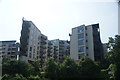
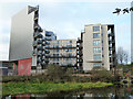
View of apartments on the River Lea from the River Lea towpath
Looking north-northwest.
Image: © Robert Lamb
Taken: 5 Jun 2016
0.02 miles
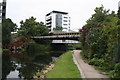
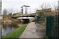
6
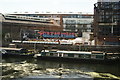
View of Swan Wharf from the footbridge next to Old Ford Lock
Looking south-southwest.
Image: © Robert Lamb
Taken: 4 Jul 2015
0.02 miles
7
View of the Northern Outfall Sewer pipes crossing the River Lea from the River Lea towpath
Looking north-northwest.
Image: © Robert Lamb
Taken: 5 Jun 2016
0.04 miles
8
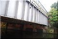
Northern Outfall Sewer crosses the River Lea
Image: © N Chadwick
Taken: 21 Oct 2012
0.04 miles
9
Northern Outfall Sewer crosses the River Lea
Image: © N Chadwick
Taken: 21 Oct 2012
0.04 miles
10
The Northern Outfall Sewer over the River Lea
Image: © Ian S
Taken: 1 Mar 2014
0.04 miles