IMAGES TAKEN NEAR TO
Cedar Close, LONDON, E3 2JA
Introduction
This page details the photographs taken nearby to Cedar Close, E3 2JA by members of the Geograph project.
The Geograph project started in 2005 with the aim of publishing, organising and preserving representative images for every square kilometre of Great Britain, Ireland and the Isle of Man.

There are currently over 7.5m images from over14,400 individuals and you can help contribute to the project by visiting https://www.geograph.org.uk
Image Map
Images are licensed for reuse under creativecommons.org/licenses/by-sa/2.0
Notes
- Clicking on the map will re-center to the selected point.
- The higher the marker number, the further away the image location is from the centre of the postcode.
Image Listing (173 Images Found)
Images are licensed for reuse under creativecommons.org/licenses/by-sa/2.0
Image
Details
Distance
1
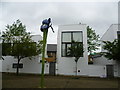
Sculpture at Eden Way, Bow
In the absence of real flowers in this rather bleak development, I suppose this is better than nothing.
Image: © Marathon
Taken: 28 May 2014
0.04 miles
2
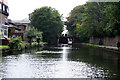
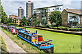
Hertford Union Canal: approaching the top lock
Looking west. The Hertford Union Canal joins the Lee Navigation with the Regent's Canal, and is very useful for boaters making for the Lee from the main system. There are just three locks, quite close together.
Image: © Dr Neil Clifton
Taken: 6 Sep 2008
0.07 miles
5
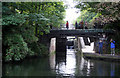
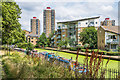
Hertford Union Canal
The Hertford Union Canal viewed from the edge of Victoria Park, with housing in Waterside Park in the background and Waverton House and Winford House beyond.
Image: © Ian Capper
Taken: 13 Jul 2019
0.07 miles
6
Hertford Union Canal
The Hertford Union Canal viewed from the edge of Victoria Park, with housing in Waterside Park in the background and Waverton House and Winford House beyond.
Image: © Ian Capper
Taken: 13 Jul 2019
0.07 miles
7

North Bow Congregational Hall
Old Hall on the junction of Armagh Road (on the left) and Old Ford Road (on the right). Built in 1833.
Used as a church hall by the Old Ford Methodist Church (on the far left).
Image: © David Anstiss
Taken: 15 Feb 2012
0.08 miles
8
View of apartments on the Hertford Union Canal from Victoria Park #7
Looking south-southeast.
Image: © Robert Lamb
Taken: 26 Aug 2017
0.08 miles
9
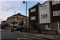
Old Ford Road
At the junction of Parnell Road
Image: © David Howard
Taken: 28 Sep 2019
0.08 miles
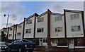
10
View of a block of flats on Parnell Road, Bow from Victoria Park
Looking south-southeast.
Image: © Robert Lamb
Taken: 26 Aug 2017
0.09 miles