IMAGES TAKEN NEAR TO
Libra Road, LONDON, E3 2HP
Introduction
This page details the photographs taken nearby to Libra Road, E3 2HP by members of the Geograph project.
The Geograph project started in 2005 with the aim of publishing, organising and preserving representative images for every square kilometre of Great Britain, Ireland and the Isle of Man.

There are currently over 7.5m images from over14,400 individuals and you can help contribute to the project by visiting https://www.geograph.org.uk
Image Map (Loading...)


Getting Data...Please wait
Leaflet Map data © OpenStreetMap
Images are licensed for reuse under creativecommons.org/licenses/by-sa/2.0
Notes
- Clicking on the map will re-center to the selected point.
- The higher the marker number, the further away the image location is from the centre of the postcode.
Image Listing (59 Images Found)
Images are licensed for reuse under creativecommons.org/licenses/by-sa/2.0
Image
Details
Distance
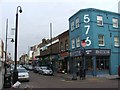
5

Roman Road, Bow
This long straight shopping street leads from Legion Terrace to Stephen's Road.
Bow has an historical trail highlighting the historic parts of the area.
Image: © David Anstiss
Taken: 15 Feb 2012
0.12 miles
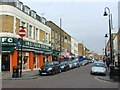
7
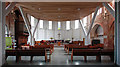
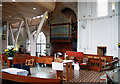
St Paul with St Mark, St Stephen's Road, Old Ford - East end
Image: © John Salmon
Taken: 22 Mar 2011
0.12 miles
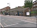
8
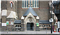
St Paul with St Mark, St Stephen's Road, Old Ford
Image: © John Salmon
Taken: 22 Mar 2011
0.13 miles
9
St Paul with St Mark, St Stephen's Road, Old Ford - Organ
Image: © John Salmon
Taken: 22 Mar 2011
0.13 miles
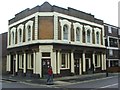
10
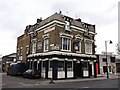
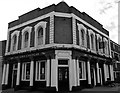
Hand and Flower Public House, Bow
On Parnell Road.
On the far right is Image
Image: © David Anstiss
Taken: 15 Feb 2012
0.13 miles