IMAGES TAKEN NEAR TO
Malmesbury Road, LONDON, E3 2DT
Introduction
This page details the photographs taken nearby to Malmesbury Road, E3 2DT by members of the Geograph project.
The Geograph project started in 2005 with the aim of publishing, organising and preserving representative images for every square kilometre of Great Britain, Ireland and the Isle of Man.

There are currently over 7.5m images from over14,400 individuals and you can help contribute to the project by visiting https://www.geograph.org.uk
Image Map (Loading...)


Getting Data...Please wait
Leaflet Map data © OpenStreetMap
Images are licensed for reuse under creativecommons.org/licenses/by-sa/2.0
Notes
- Clicking on the map will re-center to the selected point.
- The higher the marker number, the further away the image location is from the centre of the postcode.
Image Listing (155 Images Found)
Images are licensed for reuse under creativecommons.org/licenses/by-sa/2.0
Image
Details
Distance
3
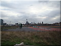
View of Canary Wharf from the Greenway
Looking south-southwest.
Image: © Robert Lamb
Taken: 8 Jan 2012
0.07 miles
4
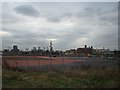
View of Canary Wharf and the Bow Quarter Estate (former Bryant & May match factory) from the Greenway
Looking south-southwest.
Image: © Robert Lamb
Taken: 8 Jan 2012
0.07 miles
5
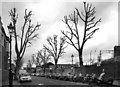
Addington Road, Bow
An unremarkable street apart from these heavily pruned Plane trees, which look especially bleak against the sky in B & W.
Image: © Des Blenkinsopp
Taken: 10 Mar 2011
0.08 miles
6

Fairfield Road from under the railway bridge
This is one of two rail bridges in quick succession
Image: © David Howard
Taken: 11 Jul 2012
0.10 miles
7
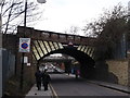
Railway bridge over Fairfield Road
Fairfield Road leads from Bow Road to Tredgar Road.
It passes under a railway between Stratford and Stepney.
In the background is another railway bridge between Stratford and Bethnal Green.
Image: © David Anstiss
Taken: 15 Feb 2012
0.11 miles
8
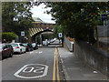
Fairfield Road, Bow
Fairfield Road dives under two railway bridges.
Image: © Stephen McKay
Taken: 15 Jul 2016
0.11 miles
9
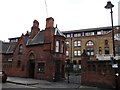
Entrance Gate to Fairfield Match Works, Bow
Former Bryant and May factory on Fairfield Road.
Was the setting of the 'London matchgirls strike of 1888'.
Most of the buildings have been converted into housing - creating the Bow Quarter Estate.
See http://en.wikipedia.org/wiki/London_matchgirls_strike_of_1888 for more details about the strike.
All of the buildings are Grade II listed. Including http://www.britishlistedbuildings.co.uk/en-205967-fairfield-match-works-2-bow at the entrance.
See also Image, (close-up of the blue plaque on the building).
Image: © David Anstiss
Taken: 15 Feb 2012
0.11 miles
10
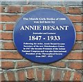
Blue Plaque for Annie Besant
On Image
See http://en.wikipedia.org/wiki/London_matchgirls_strike_of_1888 for more details about the strike.
See also http://en.wikipedia.org/wiki/Annie_Besant for more details about the strike breaker.
Image: © David Anstiss
Taken: 15 Feb 2012
0.11 miles