1
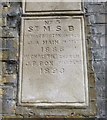
Old Boundary Marker by Coburn Road, Bow Parish
Parish Boundary Marker by the UC road, in parish of Bow (Tower Hamlets District), Coborn Road E3, on railway bridge abutment below: MX_SMSB01pb
Image
Surveyed
Milestone Society National ID: MX_SMSB02pb
Image: © Milestone Society
Taken: Unknown
0.01 miles
2
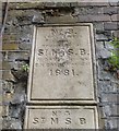
Old Boundary Marker by Coburn Road, Bow Parish
Parish Boundary Marker by the UC road, in parish of Bow (Tower Hamlets District), Coborn Road E3, on railway bridge abutment above: MX_SMSB02pb.
Image
Surveyed
Milestone Society National ID: MX_SMSB01pb
Image: © Milestone Society
Taken: Unknown
0.01 miles
3
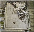
Old Boundary Marker by Coborn Road, Stepney
Parish Boundary Marker by the UC road, in parish of Stepney (Tower Hamlets District), Coborn Road E3, against abutment of railway bridge, West side of road.
Surveyed
Milestone Society National ID: MX_MEOT03pb
Image: © Milestone Society
Taken: Unknown
0.02 miles
4
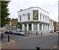
Mile End, Duke of York
Former pub at the corner of Antill and Selwyn Roads, with fine tilework advertising a long closed brewery.
Image: © Mike Faherty
Taken: 1 Sep 2012
0.06 miles
5
Smith Garrett's Prize Beers
Smith Garrett's started trading under that name in 1869 from premises previously known as The Bow Brewery Ltd.
They remained in business until 1927 when they were bought out by Taylor Walker of Limehouse.
The brewery was demolished in 1933 to make way for housing. (info thanks to Martin Cornell, Brewery History Society)
As for prizes...did they ever win any? Who knows?
This was The Duke of York, old but no longer grand.
Image: © Des Blenkinsopp
Taken: 11 Feb 2016
0.06 miles
6
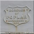
Old Boundary Marker by Antill Road, Bow parish
Municipal Boundary Marker by the UC road, in parish of Bow (Tower Hamlets District), Antill Street E3, corner with Selwyn Road, high on wall of former Duke of York PH.
Inscription reads:-
BOROUGH
OF
POPLAR
BOUNDARY
1900
Surveyed
Milestone Society National ID: MX_POPL03pb
Image: © Milestone Society
Taken: Unknown
0.06 miles
7
Old Boundary Marker by Selwyn Road, Bow Road parish
Municipal Boundary Marker by the UC road, in parish of Bow (Tower Hamlets District), Selwyn Road E3, corner with Antill Road, high on wall of former Duke of York PH.
Surveyed
Milestone Society National ID: MX_POPL04pb
Image: © Milestone Society
Taken: Unknown
0.06 miles
8
Duke of York, Bow
Image: © Chris Whippet
Taken: 4 Jan 2015
0.06 miles
9
The Poor Old Duke Of York
Another view of this street corner pub. (see also
Image)
Just visible on the wall between the bottom of the Smith Garrett sign and the window is a small shield shaped sign which is a boundary marker for the old Borough of Poplar.
Image: © Des Blenkinsopp
Taken: 11 Feb 2016
0.06 miles
10
Tredegar Terrace, Mile End
Image: © Chris Whippet
Taken: 4 Jan 2015
0.07 miles


