IMAGES TAKEN NEAR TO
Bow Road, LONDON, E3 2AE
Introduction
This page details the photographs taken nearby to Bow Road, E3 2AE by members of the Geograph project.
The Geograph project started in 2005 with the aim of publishing, organising and preserving representative images for every square kilometre of Great Britain, Ireland and the Isle of Man.

There are currently over 7.5m images from over14,400 individuals and you can help contribute to the project by visiting https://www.geograph.org.uk
Image Map
Images are licensed for reuse under creativecommons.org/licenses/by-sa/2.0
Notes
- Clicking on the map will re-center to the selected point.
- The higher the marker number, the further away the image location is from the centre of the postcode.
Image Listing (194 Images Found)
Images are licensed for reuse under creativecommons.org/licenses/by-sa/2.0
Image
Details
Distance

2
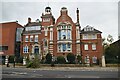
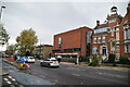
Central Foundation Girls' School
Grade II listed.
Image: © N Chadwick
Taken: 20 Nov 2022
0.01 miles
3
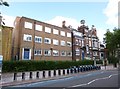
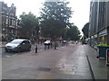
Bow, Central Foundation School
Girls' school on Bow Road. Its former name is inscribed next to the entrance as "Stepney & Bow Foundation Coburn Girls' School".
Image: © Mike Faherty
Taken: 26 Aug 2012
0.01 miles
4
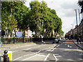
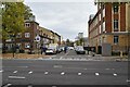
Bow Road, East London
Looking west opposite Bow Church
Image: © Dr Neil Clifton
Taken: 19 Sep 2005
0.02 miles
5
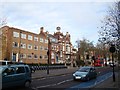
View of George Lansbury House from Mile End Road
Looking north-northeast. George Lansbury House is so named as it was the home of George Lansbury (1859-1947), an MP.
Image: © Robert Lamb
Taken: 1 Dec 2012
0.02 miles

10
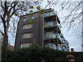
View of modern flats on Bow Road from the St Clements Hospital Site
Looking south-southeast. If you're wondering how I got access into the site (the site has been closed to the public since 2005), I have two friends from university who are working on a project to convert the hospital site into a Community Land Trust, passed by Boris Johnson last year. Read more about it here: http://www.jtp.co.uk/community-planning-projects/st-clements/
Image: © Robert Lamb
Taken: 1 Dec 2012
0.04 miles