IMAGES TAKEN NEAR TO
E2 9WB
Introduction
This page details the photographs taken nearby to E2 9WB by members of the Geograph project.
The Geograph project started in 2005 with the aim of publishing, organising and preserving representative images for every square kilometre of Great Britain, Ireland and the Isle of Man.

There are currently over 7.5m images from over14,400 individuals and you can help contribute to the project by visiting https://www.geograph.org.uk
Image Map
Images are licensed for reuse under creativecommons.org/licenses/by-sa/2.0
Notes
- Clicking on the map will re-center to the selected point.
- The higher the marker number, the further away the image location is from the centre of the postcode.
Image Listing (439 Images Found)
Images are licensed for reuse under creativecommons.org/licenses/by-sa/2.0
Image
Details
Distance
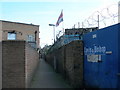
1
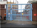
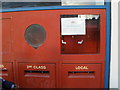
Royal Mail Post Office
Picture chosen by IK.
Image: © Ms Kathy
Taken: 22 Jan 2009
0.02 miles
3
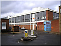
Bethnal Green: Royal Mail sorting office, Emma Street
Image: © Dr Neil Clifton
Taken: 25 Feb 2010
0.02 miles
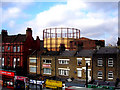
4
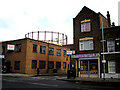
Bethnal Green: Billy's Cafe, Pritchard's Road
They probably do a very good Full English there, but it's hardly the sort of place to which Bertie Wooster would take his aunt. The gasholder in the background is one of four on the site, originally belonging to the Gas Light and Coke Company. Gas was not made there, but was piped from the works about half a mile to the west.
Image: © Dr Neil Clifton
Taken: 19 Feb 2010
0.04 miles
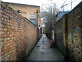
5
Grove Passage, E2
A shortcut from The Oval to Cambridge Heath Road.
Image: © Danny P Robinson
Taken: 9 Apr 2007
0.04 miles
6
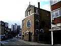
Bethnal Green: Lithuanian Roman Catholic Church of St. Casimir
On The Oval, just north of Hackney Road
Image: © Dr Neil Clifton
Taken: 19 Feb 2010
0.04 miles
7
Cambridge Heath Station: View to the northwest
The platforms at Cambridge Heath are high above street level which makes them a good place for photography. Here looking northwest from the northern end of the down platform, we see across Hackney road to the gasholder.
Image: © Dr Neil Clifton
Taken: 19 Feb 2010
0.04 miles
8
Bethnal Green: Grove Passage
This pedestrian way runs through from the southern end of The Oval, northeast under the railway, to emerge on Corbridge Crescent near its junction with Cambridge Heath Road. It is seen here from its southern end.
Image: © Dr Neil Clifton
Taken: 25 Feb 2010
0.04 miles
9
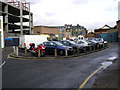
Bethnal Green: The Oval
This street runs north from Hackney Road and takes its name from the oval-shaped traffic island shown here, which is used as an unofficial and uncontrolled car park. The Oval is not quite a cul-de-sac, as exit from the northern end can be made via Corbridge Crescent onto Cambridge Heath Road.
Image: © Dr Neil Clifton
Taken: 25 Feb 2010
0.04 miles
10
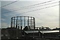
Holding on: the gas holders of Bethnal Green
After a concerted attempt was made in 2015 to cover the site in houses, the iconic structures are still in place.
Image: © Chris
Taken: 17 Jul 2017
0.05 miles