IMAGES TAKEN NEAR TO
Kay Street, LONDON, E2 8GQ
Introduction
This page details the photographs taken nearby to Kay Street, E2 8GQ by members of the Geograph project.
The Geograph project started in 2005 with the aim of publishing, organising and preserving representative images for every square kilometre of Great Britain, Ireland and the Isle of Man.

There are currently over 7.5m images from over14,400 individuals and you can help contribute to the project by visiting https://www.geograph.org.uk
Image Map
Images are licensed for reuse under creativecommons.org/licenses/by-sa/2.0
Notes
- Clicking on the map will re-center to the selected point.
- The higher the marker number, the further away the image location is from the centre of the postcode.
Image Listing (227 Images Found)
Images are licensed for reuse under creativecommons.org/licenses/by-sa/2.0
Image
Details
Distance
1
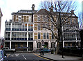
Bethnal Green: Queen Elizabeth Hospital for Children
In 1868, the North Eastern Hospital for Children opened on this site. In 1908 it was renamed the Queen's Hospital for Children, and in 1942 after amalgamation with another similar institution from Shadwell, the present name was adopted. However, in 1998 the services of this hospital were transferred to the Royal London Hospital in Whitechapel.
Image: © Dr Neil Clifton
Taken: 19 Feb 2010
0.03 miles
2
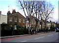
Bethnal Green: 259-273 Hackney Road
The date above the first pair of houses is 1820, which implies that the original inhabitants of these houses would have been fairly well-off, possibly possessing their own carriages, as this of course would have well pre-dated the railway, which did not reach the nearest station at London Fields until 1872, (the station at Cambridge Heath did not open until 1884). In those days, this was considered a very desirable place to reside.
Image: © Dr Neil Clifton
Taken: 19 Feb 2010
0.03 miles
4
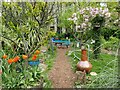
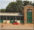
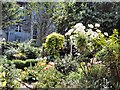
The garden at Hackney City Farm
In the first past of the 20th century, various businesses were based at the site now occupied by Hackney City Farm, ranging from furniture makers to button manufacturers. From 1940 onwards the site was occupied by a road haulage company. Later in 1982, local people formed the farm, and kept a few animals in the nearby Covent Gardens. Two years later in 1984, Hackney City Farm moved to the current site and was given a hundred year lease by Hackney Council. The attractive garden is alongside Goldsmith's Row.
A fuller history can be seen at hackneycityfarm.co.uk/about/history/ and the website of the farm is at https://hackneycityfarm.co.uk/
Image: © Marathon
Taken: 27 Apr 2023
0.06 miles
5

Bethnal Green: Pub sign at south end of Sebright Passage
Walking east along Hackney Road, it is a surprise to encounter a pub sign in what seem to be an unlikely place. It directs you up a narrow alleyway called Sebright Passage to the Sebright Arms, but sadly the last pint appears to have been pulled here, for it has recently closed.
Image: © Dr Neil Clifton
Taken: 19 Feb 2010
0.06 miles
6
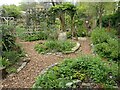
The garden at Hackney City Farm
In the first past of the 20th century, various businesses were based at the site now occupied by Hackney City Farm, ranging from furniture makers to button manufacturers. From 1940 onwards the site was occupied by a road haulage company. Later in 1982, local people formed the farm, and kept a few animals in the nearby Covent Gardens. Two years later in 1984, Hackney City Farm moved to the current site and was given a hundred year lease by Hackney Council. The attractive garden is alongside Goldsmith's Row.
A fuller history can be seen at hackneycityfarm.co.uk/about/history/ and the website of the farm is at https://hackneycityfarm.co.uk/
Image: © Marathon
Taken: 27 Apr 2023
0.06 miles
7
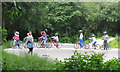
Coaching for young cyclists, Haggerston Park E2
The BMX track is accessible whenever the park is open and is free to use. Hackney BMX club run coaching sessions every Sunday, 10am - 12noon. Photographed from Goldsmith's Row. More information from Hackney Council's website http://www.hackney.gov.uk/haggerston-park.htm
Haggerston Park is in the south west corner of Hackney, bordered by Queensbridge Road, Hackney Road and Goldsmith's Row. The park was developed in two phases - the previously industrial northern half of the site became a public park in the late 1950s and the southern half of the park was fully developed for public use in the 1980s.
Image: © Robin Stott
Taken: 10 Jun 2012
0.06 miles
8
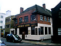
Bethnal Green: The 'Sebright Arms', Coate Street
It does not appear to have been closed very long. It looks as if it would have been a welcoming and unpretentious place.
Image: © Dr Neil Clifton
Taken: 19 Feb 2010
0.06 miles