IMAGES TAKEN NEAR TO
Whiston Road, LONDON, E2 8BN
Introduction
This page details the photographs taken nearby to Whiston Road, E2 8BN by members of the Geograph project.
The Geograph project started in 2005 with the aim of publishing, organising and preserving representative images for every square kilometre of Great Britain, Ireland and the Isle of Man.

There are currently over 7.5m images from over14,400 individuals and you can help contribute to the project by visiting https://www.geograph.org.uk
Image Map (Loading...)


Getting Data...Please wait
Leaflet Map data © OpenStreetMap
Images are licensed for reuse under creativecommons.org/licenses/by-sa/2.0
Notes
- Clicking on the map will re-center to the selected point.
- The higher the marker number, the further away the image location is from the centre of the postcode.
Image Listing (444 Images Found)
Images are licensed for reuse under creativecommons.org/licenses/by-sa/2.0
Image
Details
Distance
1
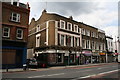
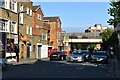
The 'King's Head', Kingsland Road, London
In an era that has brought many people of different religions to this area, it has not always been easy for public houses to survive, as some of these religions forbid the consumption of alcohol. A number of buildings which clearly used to be public houses can be seen. But the King's Head, thankfully, has survived as a no-nonsense pub where you can still get a pint of good beer and a bite to eat as well, should you so desire. But that peaceful cigar or pipe is now a thing of the past.
Image: © Dr Neil Clifton
Taken: 19 Jul 2007
0.02 miles
4
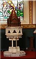
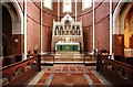
St John the Baptist, Crondall Street, Hoxton - Font
Image: © John Salmon
Taken: 27 Sep 2011
0.02 miles
6
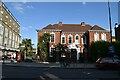
Shoreditch Health Centre
Grade II listed. https://historicengland.org.uk/listing/the-list/list-entry/1258017
Image: © N Chadwick
Taken: 7 Sep 2019
0.03 miles
8
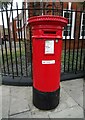
Anonymous (Victorian) postbox on Kingsland Road (A10)
Postbox No. E2 14.
Image: © JThomas
Taken: 22 Aug 2022
0.04 miles
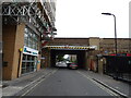
9
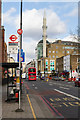
Kingsland Road
Looking north across the junction with Nuttall Street and Whiston Road towards the Süleymaniye Mosque.
Image: © Martin Addison
Taken: 19 Feb 2014
0.04 miles
10
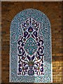
Wall panel, Suleymaniye Mosque, Kingsland Road E2
Image: © Robin Sones
Taken: 26 May 2012
0.04 miles