IMAGES TAKEN NEAR TO
Bethnal Green Road, LONDON, E2 6LH
Introduction
This page details the photographs taken nearby to Bethnal Green Road, E2 6LH by members of the Geograph project.
The Geograph project started in 2005 with the aim of publishing, organising and preserving representative images for every square kilometre of Great Britain, Ireland and the Isle of Man.

There are currently over 7.5m images from over14,400 individuals and you can help contribute to the project by visiting https://www.geograph.org.uk
Image Map
Images are licensed for reuse under creativecommons.org/licenses/by-sa/2.0
Notes
- Clicking on the map will re-center to the selected point.
- The higher the marker number, the further away the image location is from the centre of the postcode.
Image Listing (204 Images Found)
Images are licensed for reuse under creativecommons.org/licenses/by-sa/2.0
Image
Details
Distance
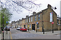
1
View of shutter art on a vacant shop unit and G. Bleetman Opticians on Bethnal Green Road
Looking north-northeast.
Image: © Robert Lamb
Taken: 27 Jun 2021
0.01 miles
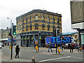
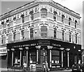
2

Yet another disused public house
On Bethnal Green Road at the junction with Rushmead. The previous name is not to be descried, but according to paper stickers it last traded as 'The Pleasure Unit'. Clearly that was some time ago. Overall, the block bears a striking resemblance to an old North London Railway station!
Image: © Dr Neil Clifton
Taken: 13 Feb 2008
0.01 miles
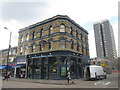
3
The Star of Bethnal Green, E2
On Bethnal Green Road.
Image: © Robin Webster
Taken: 6 Apr 2019
0.01 miles
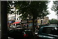
6

View of a van with street art on Bethnal Green Road
Looking south-southeast.
Image: © Robert Lamb
Taken: 27 Jun 2021
0.02 miles
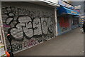
7
View of shutter art on the front of Dr. I Repair on Bethnal Green Road
Looking south-southeast.
Image: © Robert Lamb
Taken: 27 Jun 2021
0.03 miles
8
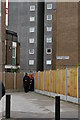
Former course of Mansford Street, E2
Mansford Street formerly ran all the way south to Bethnal Green Road, but a housing estate has been placed across its path at the southern end, leaving only a short stub (renamed Rushmead) running the final fifty yards from Florida Street to the main road. This path through the estate follows the course of the old road through to the surviving street. The blocks in the estate are named after nineteenth-century public health reformers - here, Thomas Southwood Smith (1788-1861) http://en.wikipedia.org/wiki/Southwood_Smith .
Image: © Christopher Hilton
Taken: 18 May 2012
0.03 miles
9
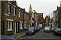
Hague Street, E2
Before the expansion of Weavers Fields park (behind the photographer), Hague Street was longer and ran from Bethnal Green Road (visible at the end of the street in this photo) down towards the railway line. Following the expansion of the park in the 1960s only this little stub remained.
In the distance the former church of St James the Great, Bethnal Green, now converted to flats.
Image: © Christopher Hilton
Taken: 18 May 2012
0.04 miles