IMAGES TAKEN NEAR TO
Vallance Road, LONDON, E2 6HR
Introduction
This page details the photographs taken nearby to Vallance Road, E2 6HR by members of the Geograph project.
The Geograph project started in 2005 with the aim of publishing, organising and preserving representative images for every square kilometre of Great Britain, Ireland and the Isle of Man.

There are currently over 7.5m images from over14,400 individuals and you can help contribute to the project by visiting https://www.geograph.org.uk
Image Map (321 Images)


Getting Data...Please wait
Leaflet Map data © OpenStreetMap
Images are licensed for reuse under creativecommons.org/licenses/by-sa/2.0
Notes
- Clicking on the map will re-center to the selected point.
- The higher the marker number, the further away the image location is from the centre of the postcode.
Image Listing (321 Images Found)
Images are licensed for reuse under creativecommons.org/licenses/by-sa/2.0
Image
Details
Distance
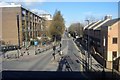
6
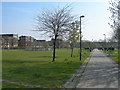
Weavers Fields, Bethnal Green
Photo taken from Vallance Road.
Image: © Danny P Robinson
Taken: 9 Apr 2007
0.03 miles
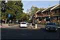
9
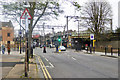
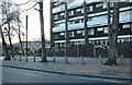
Crossroads by railway, Bethnal Green
Vallance Road, B108, runs left and right. Dunbridge Road, B135, intersects.
Image: © Robin Webster
Taken: 6 Apr 2019
0.03 miles
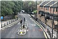
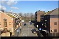
10
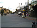
Interesting jumble of shop signs and railway hardware at the corner of Vallance Road and Dunbridge Street
Image: © Rob Purvis
Taken: 8 Oct 2013
0.04 miles