IMAGES TAKEN NEAR TO
Cyprus Street, LONDON, E2 0NW
Introduction
This page details the photographs taken nearby to Cyprus Street, E2 0NW by members of the Geograph project.
The Geograph project started in 2005 with the aim of publishing, organising and preserving representative images for every square kilometre of Great Britain, Ireland and the Isle of Man.

There are currently over 7.5m images from over14,400 individuals and you can help contribute to the project by visiting https://www.geograph.org.uk
Image Map
Images are licensed for reuse under creativecommons.org/licenses/by-sa/2.0
Notes
- Clicking on the map will re-center to the selected point.
- The higher the marker number, the further away the image location is from the centre of the postcode.
Image Listing (191 Images Found)
Images are licensed for reuse under creativecommons.org/licenses/by-sa/2.0
Image
Details
Distance
2
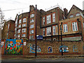
The London Chest Hospital
The London Chest Hospital, located between Bethnal Green and Mile End
Image: © Fast Track images
Taken: 26 Apr 2008
0.09 miles
3
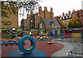
Playground, Globe School
A wet day on the playground.
Image: © wfmillar
Taken: 4 Nov 2014
0.12 miles
6
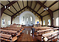
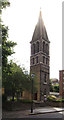
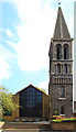
St James the Less, Bethnal Green - East end
Image: © John Salmon
Taken: 15 Sep 2014
0.12 miles
7
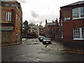
Globe Town, London
Looking down Gawber Street with Globe School on the left.
Image: © wfmillar
Taken: 4 Nov 2014
0.12 miles
8
Globe School, London
Great mosaics on school walls.
Image: © wfmillar
Taken: 4 Nov 2014
0.12 miles
9
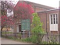
Bethnal Green Methodist Church
Bethnal Green Methodist Church at the junction of Bonner Road and Approach Road.
Image: © Fast Track images
Taken: 26 Apr 2008
0.12 miles