IMAGES TAKEN NEAR TO
Palmers Road, LONDON, E2 0FF
Introduction
This page details the photographs taken nearby to Palmers Road, E2 0FF by members of the Geograph project.
The Geograph project started in 2005 with the aim of publishing, organising and preserving representative images for every square kilometre of Great Britain, Ireland and the Isle of Man.

There are currently over 7.5m images from over14,400 individuals and you can help contribute to the project by visiting https://www.geograph.org.uk
Image Map
Images are licensed for reuse under creativecommons.org/licenses/by-sa/2.0
Notes
- Clicking on the map will re-center to the selected point.
- The higher the marker number, the further away the image location is from the centre of the postcode.
Image Listing (226 Images Found)
Images are licensed for reuse under creativecommons.org/licenses/by-sa/2.0
Image
Details
Distance
1
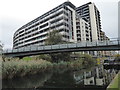
New flats next to the Regent's Canal
Construction of a national canal network began in the late 18th century, but initially the canal from the Midlands ended at Paddington, and there was no link to eastern London until the Regent's Canal was built. It was the brainchild of engineer Thomas Homer who, in 1812, presented a plan to the Grand Junction Company (which owned the canal from London to Birmingham) for the creation of a waterway from Limehouse to Paddington. To begin with the project progressed quickly, largely passing through what was then agricultural land, but it was soon hampered by financial problems. Stubborn and greedy landowners asked inflated prices for property along the preferred route, and, to make matters worse, Thomas Homer disappeared in 1815 taking the company's funds with him. New legislation passed in 1817 enabled the work to be completed by 1820 using funds borrowed from the Treasury.
The canals were initially a success, particularly for transporting coal, building materials and other bulky loads, but the rise of the railways not long after the canals were built substantially reduced their importance. Now they are primarily a leisure facility. What was then the Central Electricity Generating Board laid cables under some of the towpaths in the 1970s, as here, and made them suitable for pedestrians again.
This is the Regent's Canal, just north of the main railway line out of Liverpool Street where it crosses over the canal. The bridge is also relatively new, although it has already been scarred by graffiti. The flats could have hardly been built any closer to the canal. Mile End Park is on this side of the canal.
Image: © Marathon
Taken: 5 Nov 2019
0.03 miles
2
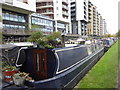
New flats next to the Regent's Canal
Construction of a national canal network began in the late 18th century, but initially the canal from the Midlands ended at Paddington, and there was no link to eastern London until the Regent's Canal was built. It was the brainchild of engineer Thomas Homer who, in 1812, presented a plan to the Grand Junction Company (which owned the canal from London to Birmingham) for the creation of a waterway from Limehouse to Paddington. To begin with the project progressed quickly, largely passing through what was then agricultural land, but it was soon hampered by financial problems. Stubborn and greedy landowners asked inflated prices for property along the preferred route, and, to make matters worse, Thomas Homer disappeared in 1815 taking the company's funds with him. New legislation passed in 1817 enabled the work to be completed by 1820 using funds borrowed from the Treasury.
The canals were initially a success, particularly for transporting coal, building materials and other bulky loads, but the rise of the railways not long after the canals were built substantially reduced their importance. Now they are primarily a leisure facility. What was then the Central Electricity Generating Board laid cables under some of the towpaths in the 1970s, as here, and made them suitable for pedestrians again.
This is the Regent's Canal, just north of the main railway line out of Liverpool Street where it crosses over the canal. The flats could have hardly been built any closer to the canal. Mile End Park is on this side of the canal.
Image: © Marathon
Taken: 5 Nov 2019
0.03 miles
3

Timber sheds, Globe town
Once a common sight on London's waterways from the Surrey Docks to Edmonton, these overhanging timber sheds await development.
[Edit] Demolished mid 2007
Image: © Pierre Terre
Taken: 7 May 2005
0.04 miles
4
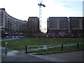
View of the Gherkin from Wennington Green
Looking south-southwest.
Image: © Robert Lamb
Taken: 16 Dec 2011
0.04 miles

6
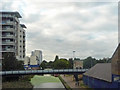
Regent's Canal at Mile End
The canal by the Millennium Park section of Mile End Park.
Image: © John Allan
Taken: 12 Sep 2012
0.04 miles
7
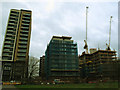
Stages of construction
Three new apartment blocks, one complete and the others in various stages of construction.
Image: © Stephen Craven
Taken: 11 Jan 2015
0.04 miles
9
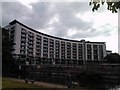
Curvy building on the Regent's Canal opposite Victoria Park
I'm unsure if this curvy building is part of Queen Mary University or Globe Town. Looking at the campus map on the university's website http://www.qmul.ac.uk/docs/about/26065.pdf I can't find any building with this shape, so I presume it is part of the latter. View taken looking west from Victoria Park.
Image: © Robert Lamb
Taken: 21 Sep 2010
0.05 miles