IMAGES TAKEN NEAR TO
Villiers Gardens, LONDON, E20 1LP
Introduction
This page details the photographs taken nearby to Villiers Gardens, E20 1LP by members of the Geograph project.
The Geograph project started in 2005 with the aim of publishing, organising and preserving representative images for every square kilometre of Great Britain, Ireland and the Isle of Man.

There are currently over 7.5m images from over14,400 individuals and you can help contribute to the project by visiting https://www.geograph.org.uk
Image Map
Images are licensed for reuse under creativecommons.org/licenses/by-sa/2.0
Notes
- Clicking on the map will re-center to the selected point.
- The higher the marker number, the further away the image location is from the centre of the postcode.
Image Listing (91 Images Found)
Images are licensed for reuse under creativecommons.org/licenses/by-sa/2.0
Image
Details
Distance
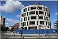
1
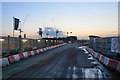
Entrance to construction site at Chobham Manor
This will be a large area of new housing on the former Olympic Park. Maps are struggling to keep up to date in the locality.
Image: © Bill Boaden
Taken: 9 Oct 2015
0.00 miles
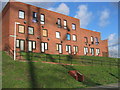
2
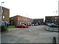
A residential court, Clays Lane Community, Feb 2007
Some of the tenants of this pleasant Peabody Trust estate have taken alternative accommodation - but many remain. This is an example of mid 20th century social housing which accommodated car ownership. The Olympic Velodrome will be behind the photographer. The Olympic Village will be the other side of Clay Lane, behind this court.
Image: © Rachel Bowles
Taken: 21 Jan 2007
0.01 miles
3
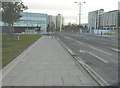
Looking south-southeast along Temple Mills Lane
The buildings are those of the former London 2012 Olympic village seen at just before 3 pm in the afternoon.
Image: © John Baker
Taken: 4 Dec 2013
0.04 miles
4
Perimeter wall of Travellers site, Clays Lane
This site will be relocated before the end of 2007. Maybe to disputed Common land on Hackney Marshes to the north.
Image: © Rachel Bowles
Taken: 21 Jan 2007
0.04 miles
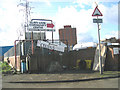
5
Clays Lane Community- earmarked for demolition
Social housing owned by the Peabody Trust to be demolished to make way for the Velodrome and Olympic village. Protestations are active : see http://www.gamesmonitor.org.uk/node/354 and later.
Image: © Rachel Bowles
Taken: 21 Jan 2007
0.04 miles
6
New apartments at Honour Lea Avenue and Temple Mills Lane
Image: © Oast House Archive
Taken: 2 Aug 2020
0.05 miles
7
Looking west towards the Velopark
The road has since been named Abercrombie Road.
Image: © John Baker
Taken: 4 Dec 2013
0.05 miles
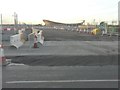
8
View from Mound at Eastway Cycle Circuit across Turnmill Lane to Leyton
Old Railway sidings used by scrap vehicle and skip yards.Bordered by a busy minor throughcut road which will eventually be changed by the Olympic developments.
Image: © Rachel Bowles
Taken: 21 Jan 2007
0.06 miles
9
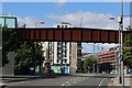
Footbridge over Temple Mills Lane
Image: © Oast House Archive
Taken: 2 Aug 2020
0.06 miles
10
Footbridge over Temple Mills Lane
Image: © Oast House Archive
Taken: 2 Aug 2020
0.06 miles