IMAGES TAKEN NEAR TO
Mirabelle Gardens, LONDON, E20 1BX
Introduction
This page details the photographs taken nearby to Mirabelle Gardens, E20 1BX by members of the Geograph project.
The Geograph project started in 2005 with the aim of publishing, organising and preserving representative images for every square kilometre of Great Britain, Ireland and the Isle of Man.

There are currently over 7.5m images from over14,400 individuals and you can help contribute to the project by visiting https://www.geograph.org.uk
Image Map
Images are licensed for reuse under creativecommons.org/licenses/by-sa/2.0
Notes
- Clicking on the map will re-center to the selected point.
- The higher the marker number, the further away the image location is from the centre of the postcode.
Image Listing (200 Images Found)
Images are licensed for reuse under creativecommons.org/licenses/by-sa/2.0
Image
Details
Distance
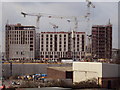
1
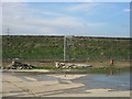
Surveying the future Service area for the Olympic Park
View looking west to the embanked railway line leading to the International Station area.Taken through the perimeter fence as at Jan 2007.
Image: © Rachel Bowles
Taken: 19 Jan 2007
0.03 miles
2
Olympic & Paralympic Athletes' Village
Taken from the northern side of Stratford International station.
Image: © David Kemp
Taken: 6 Jun 2012
0.04 miles
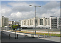
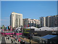
3
Athletes' Village, Olympic Park
As seen from the top floor carpark of Image
Looking across the high speed railway link and Stratford International Station.
These blocks of accommodation will later be re-developed into social housing for the area. Then it will be re-named Stratford New Town.
The green area in the middle is named Victory Park.
Image: © David Anstiss
Taken: 18 Jun 2012
0.04 miles
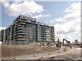
5
Athletes Village, Stratford
Work is almost complete on the exteriors of the flats that will house the athletes and officials during the Olympics and paralympics of 2012.
There are 2,818 homes at the Athletes Village including 50% affordable housing designed for key workers or people on low incomes.
Image: © Batloaf
Taken: 28 Jan 2010
0.05 miles
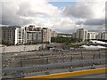
6
Athletes' Village, Olympic Park (4)
As seen from the top floor of Image
These blocks of accommodation will later be re-developed into social housing for the area.
It will then be renamed Stratford New Town.
Note: the work still going on - only 36 days to the start of the games.
Image: © David Anstiss
Taken: 19 Jun 2012
0.06 miles
7
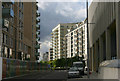
Liberty Bridge Rd, London E20
This road cuts through part of the former Athletes' Village which is in the process of being transformed into East Village. The buildings are Vesta House (centre left), Mimosa House (centre right) and the currently disused Polyclinic (right).
Image: © David Kemp
Taken: 18 Sep 2013
0.07 miles
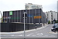
8
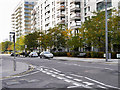
Stratford, Apartment Block on Liberty Bridge Road
Image: © David Dixon
Taken: 31 Oct 2016
0.07 miles
10
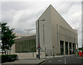
Olympic Park Polyclinic, Liberty Bridge Rd, London E20
This is the former Polyclinic which dealt with both athletes' injuries and doping control. It is currently unused but may in due course become a medical facility once more.
Image: © David Kemp
Taken: 18 Sep 2013
0.07 miles