IMAGES TAKEN NEAR TO
Benson Quay, LONDON, E1W 3TR
Introduction
This page details the photographs taken nearby to Benson Quay, E1W 3TR by members of the Geograph project.
The Geograph project started in 2005 with the aim of publishing, organising and preserving representative images for every square kilometre of Great Britain, Ireland and the Isle of Man.

There are currently over 7.5m images from over14,400 individuals and you can help contribute to the project by visiting https://www.geograph.org.uk
Image Map
Images are licensed for reuse under creativecommons.org/licenses/by-sa/2.0
Notes
- Clicking on the map will re-center to the selected point.
- The higher the marker number, the further away the image location is from the centre of the postcode.
Image Listing (500 Images Found)
Images are licensed for reuse under creativecommons.org/licenses/by-sa/2.0
Image
Details
Distance
1
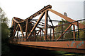
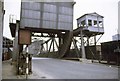
Scherzer rolling bridge, Garnet Street, Wapping
Electric bridge that is no longer in use and is over the cut that led from Shadwell Basin to the eastern dock of London Dock - now filled in. It is surprising that the Scherzer bridges were electrically powered whilst situated in the midst of the London Hydraulic Power Co supply area. There is a more photographed example at the other end of Shadwell Basin.
Image: © Chris Allen
Taken: 21 Aug 2011
0.02 miles
2
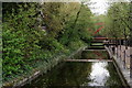
Shadwell
Weirs to the west of Shadwell Basin.
Image: © Peter Trimming
Taken: 1 May 2018
0.03 miles
3
Bascule Bridge
Located above the weirs, to the west of Shadwell Basin.
Image: © Peter Trimming
Taken: 1 May 2018
0.03 miles
4

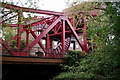
Former rolling bridge, Garnet Street, Shadwell
It now spans a finger of ornamental channel extending from Shadwell Basin. This appears to be the same bridge as in Chris Allen's Image A similar retained bridge spans the wide channel formerly between the basin and the Thames: Image
Image: © Robin Stott
Taken: 13 Oct 2018
0.03 miles
5
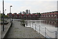
Shadwell Basin, East London
This is taken from the bridge spanning the 'New' entrance to the basin, from the Thames, (the 'Old' entrance has been filled in for some years). Until recently, water passage was available from here, through the East and Western London Docks and out into the Thames again through Hermitage Basin, not far from the Tower. But this water route is not available now as the London Docks have been filled in. Attractive modern housing has recently been built around the basin and these are some of the most expensive properties in the capital.
Image: © Dr Neil Clifton
Taken: 13 Sep 2007
0.03 miles
6

Footpaths to Shadwell Basin
The lower path, right, runs beside the ornamental channel back to Wapping Woods open space Image On the left is the south end of the Maynards Quay gated residential development.
Image: © Robin Stott
Taken: 13 Oct 2018
0.03 miles
7
Disused bascule bridge, Wapping, East London
This bridge carried the traffic using Garnet Street over the link between Shadwell Basin and the inner docks. It was periodically raised on its Southern end to allow passing boats. This operation took some fifteen minutes and was often exploited by local schoolchildren. The cry of "Sorry Sir, Caught the Bridger" was a reliable excuse to escape punishment for late arrival. This picture was taken in the late seventies, after the closure of the docks but prior to development of the area. It can be seen that all the windows of the controller's cabin have been smashed by vandals. The whole cabin has now been removed.
Image: © Derek Voller
Taken: Unknown
0.04 miles
8
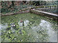
Cat eyeing up ducks
This is on the canalised water feature just west of Garnet Street.
Image: © Marathon
Taken: 14 Dec 2021
0.04 miles
9
Cut to Shadwell Basin
A cut running from Wapping Woods under Garnet Street to Shadwell Basin.
Image: © DS Pugh
Taken: 21 May 2016
0.04 miles
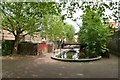
10
Steps & Apartments, Shadwell Basin
Image: © Des Blenkinsopp
Taken: 17 Oct 2013
0.05 miles