IMAGES TAKEN NEAR TO
Brodlove Lane, LONDON, E1W 3EL
Introduction
This page details the photographs taken nearby to Brodlove Lane, E1W 3EL by members of the Geograph project.
The Geograph project started in 2005 with the aim of publishing, organising and preserving representative images for every square kilometre of Great Britain, Ireland and the Isle of Man.

There are currently over 7.5m images from over14,400 individuals and you can help contribute to the project by visiting https://www.geograph.org.uk
Image Map
Images are licensed for reuse under creativecommons.org/licenses/by-sa/2.0
Notes
- Clicking on the map will re-center to the selected point.
- The higher the marker number, the further away the image location is from the centre of the postcode.
Image Listing (276 Images Found)
Images are licensed for reuse under creativecommons.org/licenses/by-sa/2.0
Image
Details
Distance
1
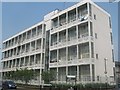
Barnardo Gardens, E1
It is probable that the road was named after Thomas Barnardo, who did much to help poor children locally during the late 19th Century. Here is a link to a history of Barnardo's, which was strongly associated with the East End of London in its early years. http://www.barnardos.org.uk/barnardo_s_history.pdf
Image: © Danny P Robinson
Taken: 16 Sep 2009
0.03 miles
2
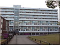
Ratcliff, Roslin House
Part of the Glamis Estate, on Brodlove Lane.
Image: © Mike Faherty
Taken: 1 Sep 2012
0.04 miles
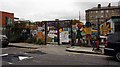
3
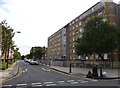
Housing, Devonport Street
Large block of social housing beside Devonport Street, near Cable Street.
Image: © David Anstiss
Taken: 23 May 2012
0.04 miles
4
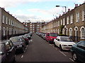
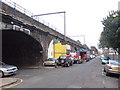
Havering Street, E1
Picture taken from near the railway bridge.
Image: © Danny P Robinson
Taken: 16 Sep 2009
0.07 miles
5
Barnardo Street, E1
About halfway between Shadwell and Limehouse stations, with the main line eventually terminating at Fenchurch Street. The bridge on the left is the access to Havering Street. It is probable that the road was named after Thomas Barnardo, who did much to help poor children locally during the late 19th Century. Here is a link to a history of Barnardo's, which was strongly associated with the East End of London in its early years. http://www.barnardos.org.uk/barnardo_s_history.pdf
Image: © Danny P Robinson
Taken: 16 Sep 2009
0.07 miles
6
Barnardo Gardens, E1
It is probable that the road was named after Thomas Barnardo, who did much to help poor children locally during the late 19th Century. Here is a link to a history of Barnardo's, which was strongly associated with the East End of London in its early years. http://www.barnardos.org.uk/barnardo_s_history.pdf
Image: © Danny P Robinson
Taken: 16 Sep 2009
0.07 miles
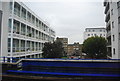
8

King Edward VII Memorial Park
An avenue of flowering trees leads up to a cenotaph memorial to King Edward VII on a raised terrace. Opened by his son King George V with Queen Mary in 1922, after this landscape was laid out on the site of wharves, houses and Shadwell Fish Market (the latter an initiative of the City of London Corporation)
an area given to the Memorial Committee by the Corporation for this purpose.
Image: © Colin D Brooking
Taken: 19 Feb 2013
0.08 miles
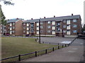
9
Glamis Playground, Glamis Road, London E1
Image: © John Salmon
Taken: 14 Oct 2008
0.09 miles
10

Glamis Playground, Glamis Road, London E1
Image: © John Salmon
Taken: 14 Oct 2008
0.09 miles