IMAGES TAKEN NEAR TO
Brodlove Lane, LONDON, E1W 3DU
Introduction
This page details the photographs taken nearby to Brodlove Lane, E1W 3DU by members of the Geograph project.
The Geograph project started in 2005 with the aim of publishing, organising and preserving representative images for every square kilometre of Great Britain, Ireland and the Isle of Man.

There are currently over 7.5m images from over14,400 individuals and you can help contribute to the project by visiting https://www.geograph.org.uk
Image Map
Images are licensed for reuse under creativecommons.org/licenses/by-sa/2.0
Notes
- Clicking on the map will re-center to the selected point.
- The higher the marker number, the further away the image location is from the centre of the postcode.
Image Listing (284 Images Found)
Images are licensed for reuse under creativecommons.org/licenses/by-sa/2.0
Image
Details
Distance
1

King Edward VII Memorial Park
An avenue of flowering trees leads up to a cenotaph memorial to King Edward VII on a raised terrace. Opened by his son King George V with Queen Mary in 1922, after this landscape was laid out on the site of wharves, houses and Shadwell Fish Market (the latter an initiative of the City of London Corporation)
an area given to the Memorial Committee by the Corporation for this purpose.
Image: © Colin D Brooking
Taken: 19 Feb 2013
0.05 miles
2
Barnardo Gardens, E1
It is probable that the road was named after Thomas Barnardo, who did much to help poor children locally during the late 19th Century. Here is a link to a history of Barnardo's, which was strongly associated with the East End of London in its early years. http://www.barnardos.org.uk/barnardo_s_history.pdf
Image: © Danny P Robinson
Taken: 16 Sep 2009
0.06 miles
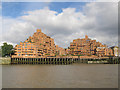
3
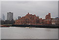
Free Trade Wharf
Piles of flats at this redeveloped site.
Image: © Robin Webster
Taken: 30 Jun 2011
0.07 miles
4
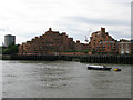
Free Trade Wharf, The Highway, Wapping
It was quite difficult to find a name for this 'landmark' building, some web sites refer to the older building on the right as The Highway, a converted warehouse but it would appear the whole complex is called Free Trade Wharf, 340 The Highway, Wapping.
Image: © Nick Smith
Taken: 25 Jul 2011
0.07 miles
5
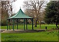
Bandstand, King Edward VII Memorial Park
For more on the history and importance of the park visit this http://en.wikipedia.org/wiki/King_Edward_Memorial_Park
Image: © Jim Osley
Taken: 31 Mar 2011
0.07 miles
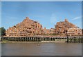
6
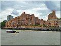
Free Trade Wharf
The distinctively shaped blocks of flats adjacent to the Thames were built in the 1980s and take their name from the building at the far right of the photo which is a listed building formerly belonging to the East India Company.
(source: http://www.free-trade-wharf.co.uk/history.html )
Image: © Stephen Craven
Taken: 12 Oct 2013
0.07 miles
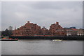
7
Ratcliff: Free Trade Wharf, 340 The Highway, E1 (1)
This was once the site of the Bowles and Charrington Wharves, both part of the original Free Trade Wharf. The old disused warehouses were bought in 1977 by the Inner London Education Authority, for a site for the City of London Polytechnic. When this plan was abandoned, the land was acquired by Regalian Homes.
Designed by the architects Holder Mathias Alcock, the first phase of the Free Trade Wharf residential development was built in the 1980s, and the first flat was sold in 1987. The building is described as having “dramatic ziggurat-style terraces” and has often been called ‘The Lego Development’ because of its shape.
Image: © Nigel Cox
Taken: 29 Sep 2018
0.07 miles
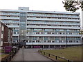
9
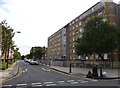
Ratcliff, Roslin House
Part of the Glamis Estate, on Brodlove Lane.
Image: © Mike Faherty
Taken: 1 Sep 2012
0.08 miles