IMAGES TAKEN NEAR TO
Elf Row, LONDON, E1W 3AP
Introduction
This page details the photographs taken nearby to Elf Row, E1W 3AP by members of the Geograph project.
The Geograph project started in 2005 with the aim of publishing, organising and preserving representative images for every square kilometre of Great Britain, Ireland and the Isle of Man.

There are currently over 7.5m images from over14,400 individuals and you can help contribute to the project by visiting https://www.geograph.org.uk
Image Map
Images are licensed for reuse under creativecommons.org/licenses/by-sa/2.0
Notes
- Clicking on the map will re-center to the selected point.
- The higher the marker number, the further away the image location is from the centre of the postcode.
Image Listing (332 Images Found)
Images are licensed for reuse under creativecommons.org/licenses/by-sa/2.0
Image
Details
Distance
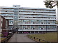
1
Glamis Playground, Glamis Road, London E1
Image: © John Salmon
Taken: 14 Oct 2008
0.01 miles
2

Glamis Playground, Glamis Road, London E1
Image: © John Salmon
Taken: 14 Oct 2008
0.02 miles
3
Glamis Playground, Glamis Road, London E1
Image: © John Salmon
Taken: 14 Oct 2008
0.02 miles
5
Barnardo Gardens, E1
It is probable that the road was named after Thomas Barnardo, who did much to help poor children locally during the late 19th Century. Here is a link to a history of Barnardo's, which was strongly associated with the East End of London in its early years. http://www.barnardos.org.uk/barnardo_s_history.pdf
Image: © Danny P Robinson
Taken: 16 Sep 2009
0.05 miles
6
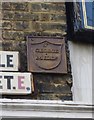
Old Boundary Marker by the B126, Cable Street, Stepney
Parish Boundary Marker by the B126, in parish of Stepney (Tower Hamlets District), Cable Street E1, junction with Hardinge Street, high on wall of former "Ship" PH, North side of road.
Boundary marker and street names were removed between 2012-2014 when the property was converted (see Streetview)
Surveyed
Milestone Society National ID: MX_SGM01pb
Image: © Milestone Society
Taken: Unknown
0.05 miles
7
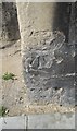
Ordnance Survey Cut Mark
This OS cut mark can be found on the SE face of the tower of St Mary's Church. It marks a point 11.821m above mean sea level.
Image: © Adrian Dust
Taken: 16 Aug 2016
0.05 miles
8
Walking Bath, Shadwell
On Cable Street.
In front of Image
Image: © David Anstiss
Taken: 23 May 2012
0.05 miles
9
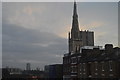
Spire of St Mary's Church
Grade II listed. http://www.britishlistedbuildings.co.uk/en-206054-st-mary-s-church-stepney
Image: © N Chadwick
Taken: 12 Feb 2012
0.06 miles