
IMAGES TAKEN NEAR TO
Royal Mint Place, LONDON, E1 8LS
Introduction
This page details the photographs taken nearby to Royal Mint Place, E1 8LS by members of the Geograph project.
The Geograph project started in 2005 with the aim of publishing, organising and preserving representative images for every square kilometre of Great Britain, Ireland and the Isle of Man.

There are currently over 7.5m images from over14,400 individuals and you can help contribute to the project by visiting https://www.geograph.org.uk
Image Map
Images are licensed for reuse under creativecommons.org/licenses/by-sa/2.0
Notes
- Clicking on the map will re-center to the selected point.
- The higher the marker number, the further away the image location is from the centre of the postcode.
Image Listing (708 Images Found)
Images are licensed for reuse under creativecommons.org/licenses/by-sa/2.0
Image
Details
Distance
1
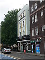
Royal Mint Street, Tower Hamlets
Off licence and pub on Royal Mint Street, in former warehouses.
Image: © Eirian Evans
Taken: 16 Aug 2013
0.00 miles

4
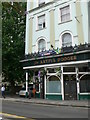
The Artful Dodger, Royal Mint Street
This is a proper east end bar that looks like it hasn't changed in about 40 years, catering for locals. Situated in a former warehouse.
Image: © Eirian Evans
Taken: 16 Aug 2013
0.01 miles
5
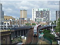
DLR at Royal Mint Street
This view was taken from a multi-storey car park next to Tower Gateway station.
Tower Gateway was the original terminus of the Docklands Light Railway, opened in 1987. In 1992, however, an extension was opened to Bank, offering better connections with London Underground. Trains running to Bank leave the original DLR route and descend down a slope into a tunnel.
The white-coloured train to the left of the image is operated by c2c, a franchise which operates the railway between London Fenchurch Street and Shoeburyness via Southend. The c2c route and the DLR lines run adjacent to each other between Tower Gateway and Limehouse, about 2km to the east.
This view is likely to change very significantly in the near future, as planning permission has been granted for a housing and hotel development in the foreground.
Image: © Malc McDonald
Taken: 4 Jul 2012
0.02 miles
6
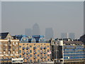
A hazy view of Canary Wharf from Tower Bridge
Looking northeast.
Image: © Robert Lamb
Taken: 13 Nov 2011
0.02 miles
8
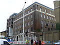
Wapping Telephone Exchange
Situated in Royal Mint Street, E1 8LQ, this TE used to have ROYal numbers until the late 1960s. Now it has 0207-480, 481, 488, 680, 702 and 709 numbers, plus some Inner London numbers.
Image: © David Hillas
Taken: 26 Feb 2009
0.05 miles
9
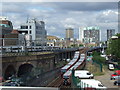
DLR at Royal Mint Street
This view was taken from a multi-storey car park next to Tower Gateway station.
Tower Gateway was the original terminus of the Docklands Light Railway, opened in 1987. In 1992, however, an extension was opened to Bank, offering better connections with London Underground. Trains running to Bank leave the original DLR route and descend down a slope into a tunnel. In this image, two trains are passing on the slope.
The white-coloured train to the left of the image is operated by c2c, a franchise which operates the railway between London Fenchurch Street and Shoeburyness via Southend. The c2c route and the DLR lines run adjacent to each other between Tower Gateway and Limehouse, about 2km to the east.
This view is likely to change very significantly in the near future, as planning permission has been granted for a housing and hotel development in the foreground.
Image: © Malc McDonald
Taken: 4 Jul 2012
0.05 miles
10
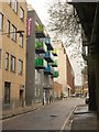
Chamber Street, E1
A reverse view of Image, with the entrance to Yeoman's Yard separating the Premier Inn from a colourful block at numbers 65-68, consisting of flats with balconies above offices on the ground and first floors. Beyond is an electricity sub-station.
Image: © Derek Harper
Taken: 1 Feb 2011
0.06 miles