IMAGES TAKEN NEAR TO
Rayne Court, LONDON, E18 2BS
Introduction
This page details the photographs taken nearby to Rayne Court, E18 2BS by members of the Geograph project.
The Geograph project started in 2005 with the aim of publishing, organising and preserving representative images for every square kilometre of Great Britain, Ireland and the Isle of Man.

There are currently over 7.5m images from over14,400 individuals and you can help contribute to the project by visiting https://www.geograph.org.uk
Image Map
Images are licensed for reuse under creativecommons.org/licenses/by-sa/2.0
Notes
- Clicking on the map will re-center to the selected point.
- The higher the marker number, the further away the image location is from the centre of the postcode.
Image Listing (10 Images Found)
Images are licensed for reuse under creativecommons.org/licenses/by-sa/2.0
Image
Details
Distance
1
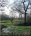
Gilbert's Slade, Epping Forest
An open area.
Image: © Stephen Richards
Taken: 30 Dec 2012
0.16 miles
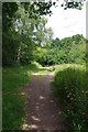
3
Gilbert's Slade
This is part of Epping Forest for more info see https://www.wansteadwildlife.org.uk/index.php/gilberts-slade70
Image: © Glyn Baker
Taken: 23 Jun 2017
0.18 miles
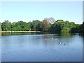
5
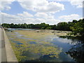
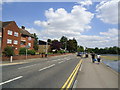
Eagle Pond
Snaresbrook Road is on the right.
Image: © Robin Webster
Taken: 9 Apr 2011
0.20 miles
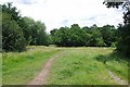
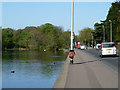
9
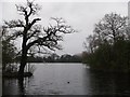
Eagle Pond, Epping Forest
As seen from the woodland on the west of the pond.
Image: © David Anstiss
Taken: 10 Mar 2013
0.24 miles