IMAGES TAKEN NEAR TO
Essex Road, LONDON, E18 1JS
Introduction
This page details the photographs taken nearby to Essex Road, E18 1JS by members of the Geograph project.
The Geograph project started in 2005 with the aim of publishing, organising and preserving representative images for every square kilometre of Great Britain, Ireland and the Isle of Man.

There are currently over 7.5m images from over14,400 individuals and you can help contribute to the project by visiting https://www.geograph.org.uk
Image Map
Images are licensed for reuse under creativecommons.org/licenses/by-sa/2.0
Notes
- Clicking on the map will re-center to the selected point.
- The higher the marker number, the further away the image location is from the centre of the postcode.
Image Listing (29 Images Found)
Images are licensed for reuse under creativecommons.org/licenses/by-sa/2.0
Image
Details
Distance
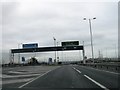
1
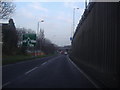
Southend Road approaching Charlie Brown's roundabout
Image: © David Howard
Taken: 31 Jan 2012
0.09 miles

4
Southend Road approaching Charlie Brown's roundabout
Image: © David Howard
Taken: 31 Jan 2012
0.09 miles
5
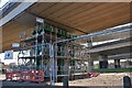
Construction work on Charlie Brown's Roundabout, Woodford
Image: © David Howard
Taken: 9 Mar 2019
0.10 miles

7
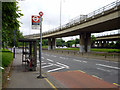
Charlie Browns Roundabout bus stop
Served by route 123 and a school service towards Gants Hill.
Image: © Robin Webster
Taken: 2 Jun 2012
0.11 miles
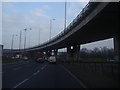
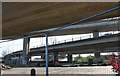
8
Flyovers by Charlie Brown's roundabout, South Woodford
Image: © David Howard
Taken: 31 Jan 2012
0.11 miles
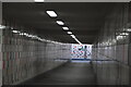
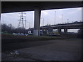
10
Under Charlie Brown's Roundabout, Woodford
Image: © David Howard
Taken: 9 Mar 2019
0.12 miles