IMAGES TAKEN NEAR TO
Raglan Road, LONDON, E17 9EE
Introduction
This page details the photographs taken nearby to Raglan Road, E17 9EE by members of the Geograph project.
The Geograph project started in 2005 with the aim of publishing, organising and preserving representative images for every square kilometre of Great Britain, Ireland and the Isle of Man.

There are currently over 7.5m images from over14,400 individuals and you can help contribute to the project by visiting https://www.geograph.org.uk
Image Map
Images are licensed for reuse under creativecommons.org/licenses/by-sa/2.0
Notes
- Clicking on the map will re-center to the selected point.
- The higher the marker number, the further away the image location is from the centre of the postcode.
Image Listing (40 Images Found)
Images are licensed for reuse under creativecommons.org/licenses/by-sa/2.0
Image
Details
Distance
1
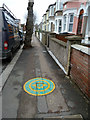
Greenwich Meridian marker, Raglan Road, Walthamstow
Apparently applied in 2000.
Image: © Robin Webster
Taken: 15 Jan 2011
0.01 miles
3
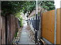
Alley from Raglan Road to Shernhall Street
It cuts a modest corner off the alternative of sticking to the two streets.
Image: © Robin Webster
Taken: 15 Jan 2011
0.05 miles
4

Alley from Raglan Road to Shernhall Street
It cuts a modest corner off the alternative of sticking to the two streets.
Image: © Robin Webster
Taken: 15 Jan 2011
0.06 miles
5
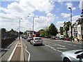
Wood Street at the junction of Lea Bridge Road
Image: © David Howard
Taken: 31 Oct 2020
0.07 miles
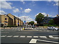
6
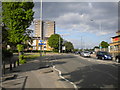
Lea Bridge Road approaching Whipps Cross roundabout
Image: © Richard Vince
Taken: 14 May 2016
0.07 miles
8
Ferndale Road at the junction of Oliver Road
Image: © David Howard
Taken: 5 Dec 2021
0.08 miles
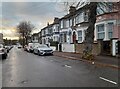
9
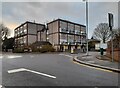
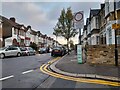
Roundabout on Shernhall Street, Walthamstow
Image: © David Howard
Taken: 5 Dec 2021
0.08 miles