IMAGES TAKEN NEAR TO
South Grove, LONDON, E17 7FT
Introduction
This page details the photographs taken nearby to South Grove, E17 7FT by members of the Geograph project.
The Geograph project started in 2005 with the aim of publishing, organising and preserving representative images for every square kilometre of Great Britain, Ireland and the Isle of Man.

There are currently over 7.5m images from over14,400 individuals and you can help contribute to the project by visiting https://www.geograph.org.uk
Image Map
Images are licensed for reuse under creativecommons.org/licenses/by-sa/2.0
Notes
- Clicking on the map will re-center to the selected point.
- The higher the marker number, the further away the image location is from the centre of the postcode.
Image Listing (121 Images Found)
Images are licensed for reuse under creativecommons.org/licenses/by-sa/2.0
Image
Details
Distance
6
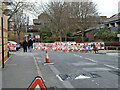
Road up, Gosport Road, E17
'Essential electricity works'.
Image: © Robin Webster
Taken: 5 Feb 2011
0.09 miles
8
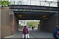
Bridge, Walthamstow
The bridge carries the London Overground over Falmouth Way (a pedestrianised area)
Image: © Richard Rogerson
Taken: 11 Sep 2019
0.09 miles
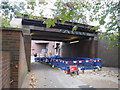
10
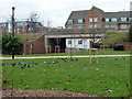
Railway bridge over South Grove, Walthamstow
Viewed from the pedestrian route towards the High Street, which uses a separate bridge - probably the old bridge for the road. The railway is the Chingford branch from Liverpool Street.
Image: © Robin Webster
Taken: 5 Feb 2011
0.09 miles