IMAGES TAKEN NEAR TO
Old Brewery Way, LONDON, E17 7FF
Introduction
This page details the photographs taken nearby to Old Brewery Way, E17 7FF by members of the Geograph project.
The Geograph project started in 2005 with the aim of publishing, organising and preserving representative images for every square kilometre of Great Britain, Ireland and the Isle of Man.

There are currently over 7.5m images from over14,400 individuals and you can help contribute to the project by visiting https://www.geograph.org.uk
Image Map
Images are licensed for reuse under creativecommons.org/licenses/by-sa/2.0
Notes
- Clicking on the map will re-center to the selected point.
- The higher the marker number, the further away the image location is from the centre of the postcode.
Image Listing (103 Images Found)
Images are licensed for reuse under creativecommons.org/licenses/by-sa/2.0
Image
Details
Distance
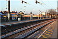
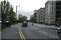
2
St James Street at the junction of Brunner Road
Image: © David Howard
Taken: 5 Dec 2021
0.04 miles
3
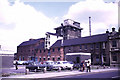
Essex Brewery, Walthamstow
A long defunct brewery on Brunner Road. St James Health Centre is still on the satellite image in 2010. The original was very dusty but extensive use of the clone tool has improved it no end at this resolution.
Image: © Chris Hodrien
Taken: 9 Jun 1973
0.05 miles
6
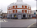
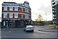
What was "The Essex Brewery Tap" Walthamstow
The Essex Brewery Tap was situated at No.2 Markhouse Road. It was the brewery tap for Tolly Cobbold brewery which was situated opposite in Grove Road. This eventually closed and demolished in the 1970s. The pub itself closed sometime between 2005 and 2006. In 2009 it was developed in to mainly 2 bedroom flats. The houses visible just to the left of the pub are built on the site of the old Markhouse Road secondary school.
Image: © Richard Dunn
Taken: 8 Aug 2009
0.06 miles
7
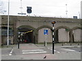
Pedestrian subway, Walthamstow
A pedestrian subway beneath St. James Street railway station in Walthamstow, in the suburbs of north east London.
Image: © Malc McDonald
Taken: 7 Mar 2020
0.06 miles
8
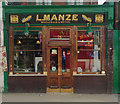
Luigi Manze's Pie and Mash establishment
At 76 Walthamstow High Street since 1929 - Luigi Manze built and opened 76 High Street as a Pie & Mash Shop in 1929. Originally from Ravello in Italy, the Manze family emigrated to the UK in 1878. They went on to found an empire of 14 Pie & Mash Shops across London, particularly in the East End, including the Walthamstow branch. The building boasts a marble/tile interior fitted with dining booths. The exterior has been restored to its original condition in 2004/2005.
Image: © Jim Osley
Taken: 1 Mar 2010
0.06 miles
10
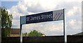
St James Street station, Walthamstow
Far too many "st" in this sentence for my liking, St James Street station, E17.
0n the Chingford - Liverpool Street line.
Image: © Phillip Perry
Taken: 30 May 2010
0.06 miles