IMAGES TAKEN NEAR TO
Blackhorse Lane, LONDON, E17 6HJ
Introduction
This page details the photographs taken nearby to Blackhorse Lane, E17 6HJ by members of the Geograph project.
The Geograph project started in 2005 with the aim of publishing, organising and preserving representative images for every square kilometre of Great Britain, Ireland and the Isle of Man.

There are currently over 7.5m images from over14,400 individuals and you can help contribute to the project by visiting https://www.geograph.org.uk
Image Map (Loading...)


Getting Data...Please wait
Leaflet Map data © OpenStreetMap
Images are licensed for reuse under creativecommons.org/licenses/by-sa/2.0
Notes
- Clicking on the map will re-center to the selected point.
- The higher the marker number, the further away the image location is from the centre of the postcode.
Image Listing (139 Images Found)
Images are licensed for reuse under creativecommons.org/licenses/by-sa/2.0
Image
Details
Distance
1
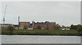
View of the new Mannequin House student residence block from the Walthamstow Wetlands
Looking east.
Image: © Robert Lamb
Taken: 29 Oct 2017
0.03 miles
3
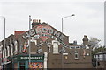
View of street art on the side of a small supermarket on Blackhorse Lane from outside Blackhorse Road station
Looking north-northeast.
Image: © Robert Lamb
Taken: 29 Oct 2017
0.07 miles
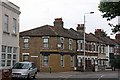
6
Blackhorse Road, E17
North of Image and the junction with Forest Road.
Image: © Mike Quinn
Taken: 18 Jun 2015
0.07 miles