IMAGES TAKEN NEAR TO
Aveling Park Road, LONDON, E17 4NS
Introduction
This page details the photographs taken nearby to Aveling Park Road, E17 4NS by members of the Geograph project.
The Geograph project started in 2005 with the aim of publishing, organising and preserving representative images for every square kilometre of Great Britain, Ireland and the Isle of Man.

There are currently over 7.5m images from over14,400 individuals and you can help contribute to the project by visiting https://www.geograph.org.uk
Image Map
Images are licensed for reuse under creativecommons.org/licenses/by-sa/2.0
Notes
- Clicking on the map will re-center to the selected point.
- The higher the marker number, the further away the image location is from the centre of the postcode.
Image Listing (49 Images Found)
Images are licensed for reuse under creativecommons.org/licenses/by-sa/2.0
Image
Details
Distance
1
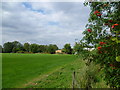
Lloyd Park
Lloyd Park was named after the family of Frank Lloyd who donated the house and ornamental grounds to the Council for use as a public park in 1898. This amounted to ten acre and was given on condition that the Council then purchase a similar area of adjoining land for use as playing fields. Lloyd Park was opened to the public in 1900.
The moat is one of the oldest recorded Historical Monuments of Walthamstow having been there prior to 1714. The present Mansion House dates from around 1760 but there was probably an earlier house on the site. The house has been known as The Water House, Lloyd Park Mansion and most recently the William Morris Gallery, after William Morris, whose family lived in the house from 1848 to 1856. The house was turned into a Museum of Morris’ life and works in 1950. There is a Friends of Lloyd Park and they have produced a much fuller history with old pictures which can be seen at http://friendsoflloydpark.org.uk/about/history/
Image: © Marathon
Taken: 9 Sep 2015
0.07 miles
2
View of the Hillyfield Primary Academy from the path leading to Cazenove Road in Lloyd Park
Looking south-southeast.
Image: © Robert Lamb
Taken: 28 Jul 2018
0.08 miles
3
View of Sir George Monoux Sixth Form College and the railings matching up from Chingford Road #2
Looking north-northeast.
Image: © Robert Lamb
Taken: 28 Jul 2018
0.10 miles
4
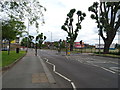
Chingford Road (A112) Walthamstow
Chingford Road looking north towards the "Crooked Billet" Roundabout. The building of the right is St. John's Church. See Image
Image: © Richard Dunn
Taken: Unknown
0.11 miles
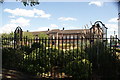
6
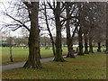
Lloyd Park
The dull and murky conditions have not put off a group of children engaged in Saturday morning football practice. The park was officially opened in 1900, most of the land having been donated by Edward Lloyd, a newspaper publisher who had purchased the house and surrounding land in 1857.
Image: © Stephen McKay
Taken: 7 Dec 2019
0.12 miles
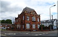
7
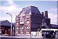
Walthamstow Tramway Offices
On Chingford Road. This view has changed enormously but the office buildings of 1905 survive and are now accommodation. See - Image
Image: © Chris Hodrien
Taken: 9 Jun 1973
0.13 miles
8
View of Sir George Monoux Sixth Form College and the railings matching up from Chingford Road
Looking south-southeast.
Image: © Robert Lamb
Taken: 28 Jul 2018
0.13 miles
9
Former Tramway Offices building, Walthamstow
On Chingford Road, the Tramways office was a hub for trams, later trolley buses, and then motor buses. Now redeveloped into flats.
Image: © JThomas
Taken: 6 Jul 2019
0.14 miles
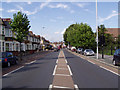
10
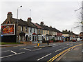
Chingford Road, Walthamstow
A line of terraced houses looks onto the busy A112 just to the north of central Walthamstow. The billboard is advertising burgers from a well-known chain apparently with a Christmas theme.
Image: © Stephen McKay
Taken: 7 Dec 2019
0.14 miles