IMAGES TAKEN NEAR TO
Albion Road, LONDON, E17 3HZ
Introduction
This page details the photographs taken nearby to Albion Road, E17 3HZ by members of the Geograph project.
The Geograph project started in 2005 with the aim of publishing, organising and preserving representative images for every square kilometre of Great Britain, Ireland and the Isle of Man.

There are currently over 7.5m images from over14,400 individuals and you can help contribute to the project by visiting https://www.geograph.org.uk
Image Map
Images are licensed for reuse under creativecommons.org/licenses/by-sa/2.0
Notes
- Clicking on the map will re-center to the selected point.
- The higher the marker number, the further away the image location is from the centre of the postcode.
Image Listing (106 Images Found)
Images are licensed for reuse under creativecommons.org/licenses/by-sa/2.0
Image
Details
Distance
7
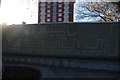
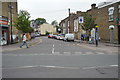
View of artistic concrete work on the corner of Wood Street and Forest Road
Looking north-northwest.
Image: © Robert Lamb
Taken: 19 Nov 2017
0.06 miles
8
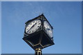
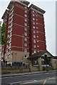
Looking up at the clock tower on the corner of Wood Street and Forest Road
Looking north-northeast.
Image: © Robert Lamb
Taken: 19 Nov 2017
0.06 miles
9
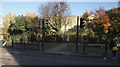
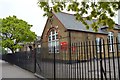
View of "WOODSIDE" painted on the railings of The Woodside School from Wood Street
Looking north-northeast.
Image: © Robert Lamb
Taken: 19 Nov 2017
0.06 miles