IMAGES TAKEN NEAR TO
The Drive, LONDON, E17 3DU
Introduction
This page details the photographs taken nearby to The Drive, E17 3DU by members of the Geograph project.
The Geograph project started in 2005 with the aim of publishing, organising and preserving representative images for every square kilometre of Great Britain, Ireland and the Isle of Man.

There are currently over 7.5m images from over14,400 individuals and you can help contribute to the project by visiting https://www.geograph.org.uk
Image Map
Images are licensed for reuse under creativecommons.org/licenses/by-sa/2.0
Notes
- Clicking on the map will re-center to the selected point.
- The higher the marker number, the further away the image location is from the centre of the postcode.
Image Listing (120 Images Found)
Images are licensed for reuse under creativecommons.org/licenses/by-sa/2.0
Image
Details
Distance
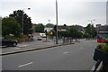
1
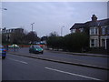
Forest Road at junction of Shernhall Street
Image: © David Howard
Taken: 22 Mar 2011
0.10 miles
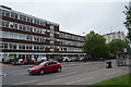
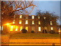
6
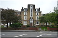
Thorpe Coombe Hospital
Grade II listed. https://britishlistedbuildings.co.uk/101357627-thorpe-coombe-hospital-original-house-only-wood-street-ward
Image: © N Chadwick
Taken: 30 May 2018
0.12 miles
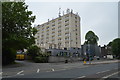
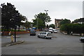
8
Looking up the handrails of the steps leading down to Waltham Forest College
Looking north-northwest.
Image: © Robert Lamb
Taken: 19 Nov 2017
0.12 miles
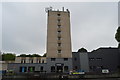
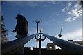
10
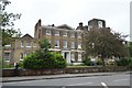
Thorpe Coombe Hospital
Grade II listed. https://britishlistedbuildings.co.uk/101357627-thorpe-coombe-hospital-original-house-only-wood-street-ward
Image: © N Chadwick
Taken: 30 May 2018
0.13 miles