IMAGES TAKEN NEAR TO
Princelet Street, LONDON, E1 6QJ
Introduction
This page details the photographs taken nearby to Princelet Street, E1 6QJ by members of the Geograph project.
The Geograph project started in 2005 with the aim of publishing, organising and preserving representative images for every square kilometre of Great Britain, Ireland and the Isle of Man.

There are currently over 7.5m images from over14,400 individuals and you can help contribute to the project by visiting https://www.geograph.org.uk
Image Map
Images are licensed for reuse under creativecommons.org/licenses/by-sa/2.0
Notes
- Clicking on the map will re-center to the selected point.
- The higher the marker number, the further away the image location is from the centre of the postcode.
Image Listing (1332 Images Found)
Images are licensed for reuse under creativecommons.org/licenses/by-sa/2.0
Image
Details
Distance
1
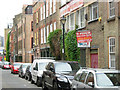
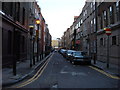
Wilkes Street, Spitalfields
Wilkes Street runs parallel with and to the east of Commercial Street. The old Suskin textile works is a reminder of the traditional industry of this district.
Image: © Stephen McKay
Taken: 6 Jul 2010
0.01 miles
2
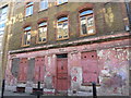
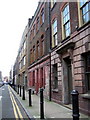
4 Princelet Street, Spitalfields
4 Princelet Street is a fine example of a Spitalfields house originally built in 1723 for Ben Truman, owner of a nearby brewery. In common with may other houses in the area it passed to a Huguenot family who were silk weavers; the top-floor weaving loft still survives. Today the property is available for hire as a location for filming, photography and private functions.
Image: © Stephen McKay
Taken: 13 Nov 2015
0.01 miles
3
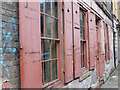
Huguenot weaver's house in Spitalfields
Spitalfields has some wonderful streets of 18th century Huguenot weavers' houses, especially in ones like Wilkes Street. This one just around the corner in Princelet Street needs a little attention to bring it up to the standard of the others.
Image: © Marathon
Taken: 26 Jan 2018
0.01 miles
4
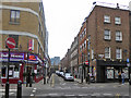
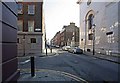
Princelet Street, E1
Looking west from Brick Lane.
Image: © Robin Webster
Taken: 6 Apr 2019
0.01 miles

7

Fournier Street, Spitalfields
Looking along Fournier Street from its junction with Wilkes Street towards Brick Lane. Fournier Street was a centre for silk weaving in the 18th century.
Image: © Stephen McKay
Taken: 6 Jul 2010
0.01 miles
8
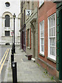
Princelet Street, south side looking east.
No 2, in the foreground, was the home of Anna Maria Garthwaite (1690 to 1763) the daughter of a wealthy rector in Lincolnshire. She moved with her sister to Spitalfields where she became a leading designer for the local silk industry. She catalogued her designs, recording details of the weavers and mercers, and these are now held by the V & A Museum.
Image: © Natasha Ceridwen de Chroustchoff
Taken: 21 Jan 2007
0.01 miles
10
Wilkes Street, Spitalfields
Looking towards the junction with Fournier Street and the side of Nicholas Hawksmoor's 18th century Christ Church. Note the old London Transport platform 3 sign.
Image: © Stephen McKay
Taken: 6 Jul 2010
0.01 miles