IMAGES TAKEN NEAR TO
Shoreditch High Street, LONDON, E1 6JN
Introduction
This page details the photographs taken nearby to Shoreditch High Street, E1 6JN by members of the Geograph project.
The Geograph project started in 2005 with the aim of publishing, organising and preserving representative images for every square kilometre of Great Britain, Ireland and the Isle of Man.

There are currently over 7.5m images from over14,400 individuals and you can help contribute to the project by visiting https://www.geograph.org.uk
Image Map
Images are licensed for reuse under creativecommons.org/licenses/by-sa/2.0
Notes
- Clicking on the map will re-center to the selected point.
- The higher the marker number, the further away the image location is from the centre of the postcode.
Image Listing (971 Images Found)
Images are licensed for reuse under creativecommons.org/licenses/by-sa/2.0
Image
Details
Distance
1
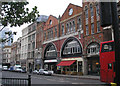
Wells and Company Commercial Iron Works, Shoreditch
On the west side of Shoreditch High Street, this building dates from a time when it was considered worthwhile to make industrial buildings look attractive.
Image: © Dr Neil Clifton
Taken: 5 Nov 2008
0.01 miles
2
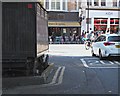
Tea Bar, Calvert Avenue, Shoreditch, London
When Syd Tothill, a British soldier who had been gassed during WWI, returned to civilian life in 1919 he used £117 of his invalidity pension to pay for the construction of a top quality mahogany tea stall with fine etched windows and gleaming brass fittings. Mains electricity was added in 1922, hooked up to an adjoining lamp post, and the old water churn that previously stood at the rear of the stall was superseded by a supply of water from the mains. In spite of it being referred to as “a coffee bar,” which was considered a classier description for this type of stall, Syd’s most popular beverages were, it seems, tea, cocoa and “Bovex” (a “poor man’s version of Bovril”). In the 1960s, when Calvert Avenue was resurfaced, Syd’s stall could not be moved on account of the mains connections and so kerbstones were placed around it instead. The stall still operates from Monday to Fridays. See also: https://spitalfieldslife.com/2010/05/12/syds-coffee-stall-shoreditch-high-st/
Image: © David Hallam-Jones
Taken: 21 Sep 2019
0.02 miles
3
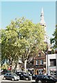
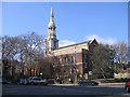
St Leonard's Church, Shoreditch, London
Apparently the Anglo-Saxon word “suer,” meaning stream, led to this former hamlet being named “Shoreditch”. This ‘blessing’ however, later undermined its first medieval church, leading to its demolition. Even St Leonard’s, the present church, dating from 1740 and designed by George Dance the Elder, experienced problems with flooding with the need for the ground level to be built up to counter this. The church is known as “The Actors’ Church”, on account of the number of thespians buried within its precincts, many of whom performed at “The Theatre” and “The Curtain Theatre” in Shoreditch in the post-Medieval period. In addition, James Parkinson, the Surgeon and Apothecary, who described the disease that was posthumously given his name was born (and later practised) in nearby Hoxton Square. He was a church warden here and is buried in a unmarked grave in the adjacent graveyard, now a public park.
Image: © David Hallam-Jones
Taken: 21 Sep 2019
0.02 miles
4
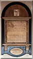
St Leonard, Shoreditch High Street, Shoreditch - Wall monument
Image: © John Salmon
Taken: 28 Sep 2011
0.03 miles
5
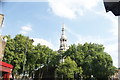
St Leonard's church, Shoreditch High Street
View NW from Calvert Avenue. This fine church, which is Shoreditch Parish Church, dates from 1740 (the present building) and is home of the bells referred to in the well-known children's song 'Oranges and Lemons': 'When I grow rich, said the bells of Shoreditch'
Image: © Rodney Burton
Taken: 18 Mar 2006
0.03 miles
6
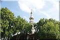
View of St. Leonard C of E church from Old Street
Looking south-southeast.
Image: © Robert Lamb
Taken: 26 Aug 2017
0.03 miles
7
View of the St. Leonard C of E church from Kingsland Road
Looking south-southeast.
Image: © Robert Lamb
Taken: 26 Aug 2017
0.03 miles
8
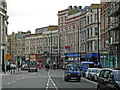
Shoreditch High Street
Looking south from the junction with Old Street, Kingsland Road and Hackney Road. Shoreditch High Street is a continuation northwards of Bishopsgate, but the affluence of the City is quickly left behind and the street is lined with run-down shops and seedy pubs.
Image: © Stephen McKay
Taken: 15 Feb 2007
0.04 miles
9
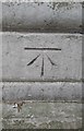
Ordnance Survey Cut Mark
This OS cut mark can be found on the west face of St Leonard's Church. It marks a point 18.314m above mean sea level.
Image: © Adrian Dust
Taken: 16 Aug 2016
0.04 miles
10
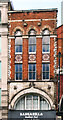
Victorian facade, Shoreditch High Street
Image: © Jim Osley
Taken: 18 Feb 2012
0.04 miles