IMAGES TAKEN NEAR TO
Cody Road, LONDON, E16 4SR
Introduction
This page details the photographs taken nearby to Cody Road, E16 4SR by members of the Geograph project.
The Geograph project started in 2005 with the aim of publishing, organising and preserving representative images for every square kilometre of Great Britain, Ireland and the Isle of Man.

There are currently over 7.5m images from over14,400 individuals and you can help contribute to the project by visiting https://www.geograph.org.uk
Image Map
Images are licensed for reuse under creativecommons.org/licenses/by-sa/2.0
Notes
- Clicking on the map will re-center to the selected point.
- The higher the marker number, the further away the image location is from the centre of the postcode.
Image Listing (39 Images Found)
Images are licensed for reuse under creativecommons.org/licenses/by-sa/2.0
Image
Details
Distance
1
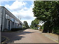
Cody Road, Canning Town
This road leads into a large industrial estate from Stephenson Street.
Image: © David Anstiss
Taken: 26 Aug 2012
0.03 miles
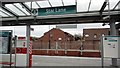
2
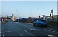
Cody Road, West Ham
Looking towards Star Lane DLR station
Image: © David Howard
Taken: 22 Jan 2023
0.05 miles
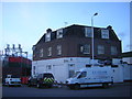
3

Star Lane Accreditation Centre, Canning Town
This building on Stephenson Road, was used as a certification office by LOCOG to give 2012 London Olympic workers photo-ids and authentication, to allow them access to various sites.
It is now being used for the London 2012 Paralympic Games, various workers and volunteers are going into to be assessed and photographed.
Image: © David Anstiss
Taken: 26 Aug 2012
0.06 miles
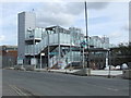
4
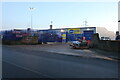
Selco builders warehouse on Cody Road, West Ham
Image: © David Howard
Taken: 22 Jan 2023
0.06 miles
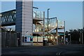
6

Jubilee Line and Docklands Light Railway
This is the view from the overbridge at Star Lane DLR station, with the Jubilee Line on the left and the DLR on the right.
A railway was first built along this route in 1846, linking Canning Town with Stratford, ultimately turning into Network Rail's North London Railway. The Jubilee Line took over their tracks in 1999, and the DLR did likewise in 2011.
Image: © Nigel Cox
Taken: 29 Aug 2019
0.07 miles
7
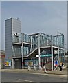
Star Lane Docklands Light Railway (DLR) Station
Image: © Jim Osley
Taken: 24 Apr 2015
0.08 miles
8
Star Lane station
On the Stratford branch of the DLR
Image: © Phillip Perry
Taken: 31 Mar 2012
0.08 miles
9
Former Dartmouth Arms pub, Bidder Street
Subsequently, by the look of it, rebranded as the Pier One night spot, but now boarded up (although still inhabited in the upper floors).
Image: © Christopher Hilton
Taken: 4 Feb 2014
0.08 miles
10
Star Lane DLR (under construction)
The Docklands Light Railway station at Star Lane, on the branch from Canning Town to Stratford International, still under construction at the time of the photograph.
Image: © Malc McDonald
Taken: 2 Oct 2010
0.08 miles