IMAGES TAKEN NEAR TO
Liverpool Road, LONDON, E16 4LU
Introduction
This page details the photographs taken nearby to Liverpool Road, E16 4LU by members of the Geograph project.
The Geograph project started in 2005 with the aim of publishing, organising and preserving representative images for every square kilometre of Great Britain, Ireland and the Isle of Man.

There are currently over 7.5m images from over14,400 individuals and you can help contribute to the project by visiting https://www.geograph.org.uk
Image Map
Images are licensed for reuse under creativecommons.org/licenses/by-sa/2.0
Notes
- Clicking on the map will re-center to the selected point.
- The higher the marker number, the further away the image location is from the centre of the postcode.
Image Listing (115 Images Found)
Images are licensed for reuse under creativecommons.org/licenses/by-sa/2.0
Image
Details
Distance
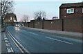
2
Baron Walk, Newham
A public footpath alongside Star Park Image
Image: © Stephen Craven
Taken: 15 Jun 2014
0.12 miles
3
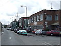
Stephenson Street, Canning Town
Stephenson Street looking south to Canning Town.
Image: © Malc McDonald
Taken: 2 Oct 2010
0.12 miles
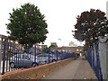
4
Star Park, Newham
A small urban park.
Image: © Stephen Craven
Taken: 15 Jun 2014
0.12 miles
5
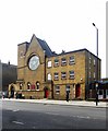
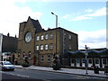
St Margaret and All Saints, Barking Road, Canning Town
Roman Catholic Church built to the designs of architect Francis William Tasker (d. 1904) between 1875 and 1876; restoration after war damage according to the designs of architect T.G. Birchall-Scott. Information gleaned from this https://londonchurchbuildings.wordpress.com/2013/05/12/st-margaret-and-all-saints-barking-road-canning-town-roman-catholic/.
Image: © Jim Osley
Taken: 24 Apr 2015
0.12 miles
7
The Durham Arms, E16, 2011
On the corner of Wharf Street and Stephenson Street. Now closed.
Image: © Robin Webster
Taken: 5 Feb 2011
0.13 miles
8
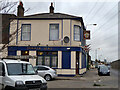
St Margaret's Catholic Church, Canning Town
On the A124 Barking Road.
Image: © David Anstiss
Taken: 26 Aug 2012
0.13 miles
9
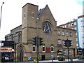
St Margaret's Catholic Church, Canning Town (2)
On the A124 Barking Road.
Image: © David Anstiss
Taken: 26 Aug 2012
0.13 miles
10
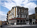
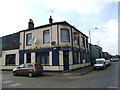
The Royal Oak Public House, Canning Town
Grade II listed former public house on the junction of the A124 Barking Road and Oak Crescent (on the left). Now used as a betting shop.
See http://www.britishlistedbuildings.co.uk/en-204919-royal-oak-public-house-greater-london-au for more details about the listed building.
Image: © David Anstiss
Taken: 26 Aug 2012
0.13 miles