IMAGES TAKEN NEAR TO
Beckton Road, LONDON, E16 4DE
Introduction
This page details the photographs taken nearby to Beckton Road, E16 4DE by members of the Geograph project.
The Geograph project started in 2005 with the aim of publishing, organising and preserving representative images for every square kilometre of Great Britain, Ireland and the Isle of Man.

There are currently over 7.5m images from over14,400 individuals and you can help contribute to the project by visiting https://www.geograph.org.uk
Image Map
Images are licensed for reuse under creativecommons.org/licenses/by-sa/2.0
Notes
- Clicking on the map will re-center to the selected point.
- The higher the marker number, the further away the image location is from the centre of the postcode.
Image Listing (63 Images Found)
Images are licensed for reuse under creativecommons.org/licenses/by-sa/2.0
Image
Details
Distance
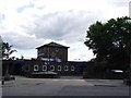
1
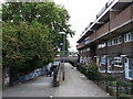
Subway to Bothwell Close
This path leads under the A13 Newham Way (dual carriageway) towards a housing suburb of Canning Town.
Image: © David Anstiss
Taken: 26 Aug 2012
0.03 miles
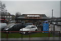
4
McDonald's, Canning Town
Take-away restaurant at the junction of Barking Road and Beckton Road.
Image: © David Anstiss
Taken: 26 Aug 2012
0.04 miles
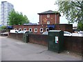
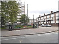
5
The Beckton Arms, Canning Town
Public house on Beckton Road.
Image: © David Anstiss
Taken: 26 Aug 2012
0.04 miles
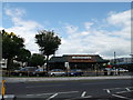
7
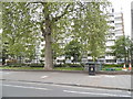
Block of flats on Barking Road, Canning Town
The tree is nearly as wide as the block, it is not a perspective illusion.
Image: © David Howard
Taken: 27 Apr 2014
0.07 miles
8
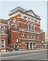
Former public hall, Canning Town
Grade II listed building built to the designs of architect Lewis Angell, along with the adjacent public library. Extensive architectural description, with pointer to its importance in social history, at this http://list.historicengland.org.uk/resultsingle.aspx?uid=1402042.
Image: © Jim Osley
Taken: 24 Apr 2015
0.07 miles
9
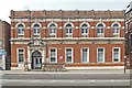
Public library, Canning Town
Grade II listed building built to the designs of architect Lewis Angell between 1892 and 1894 along with the adjacent public hall. Extensively described at this http://list.historicengland.org.uk/resultsingle.aspx?uid=1402042.
Image: © Jim Osley
Taken: 24 Apr 2015
0.07 miles
10
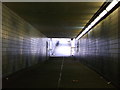
Subway under the A13 Newham Way
This passageway leads from Bothwell Close to Beckton Road.
It passes under the A13 dual carriageway towards Canning Town shops.
Image: © David Anstiss
Taken: 26 Aug 2012
0.07 miles