IMAGES TAKEN NEAR TO
Cambus Road, LONDON, E16 4AX
Introduction
This page details the photographs taken nearby to Cambus Road, E16 4AX by members of the Geograph project.
The Geograph project started in 2005 with the aim of publishing, organising and preserving representative images for every square kilometre of Great Britain, Ireland and the Isle of Man.

There are currently over 7.5m images from over14,400 individuals and you can help contribute to the project by visiting https://www.geograph.org.uk
Image Map
Images are licensed for reuse under creativecommons.org/licenses/by-sa/2.0
Notes
- Clicking on the map will re-center to the selected point.
- The higher the marker number, the further away the image location is from the centre of the postcode.
Image Listing (35 Images Found)
Images are licensed for reuse under creativecommons.org/licenses/by-sa/2.0
Image
Details
Distance
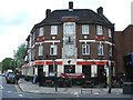
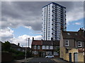
1
The Armed and Navy, Public House, Plaistow
Pub on New Barn Street.
Behind is Stubbs Point, block of housing.
Image: © David Anstiss
Taken: 26 Aug 2012
0.09 miles
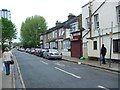
6
Lincoln Road, Plaistow
A small road in the district.
In the background is Stubbs Point (block of housing).
Image: © David Anstiss
Taken: 26 Aug 2012
0.14 miles
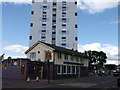
7
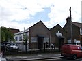
Assembles of God (Back to God) Church, Plaistow
Modern church on the junction of Cumberland Road and Holborn Road (on the left).
Image: © David Anstiss
Taken: 26 Aug 2012
0.15 miles