IMAGES TAKEN NEAR TO
Oystercatcher Close, LONDON, E16 3SH
Introduction
This page details the photographs taken nearby to Oystercatcher Close, E16 3SH by members of the Geograph project.
The Geograph project started in 2005 with the aim of publishing, organising and preserving representative images for every square kilometre of Great Britain, Ireland and the Isle of Man.

There are currently over 7.5m images from over14,400 individuals and you can help contribute to the project by visiting https://www.geograph.org.uk
Image Map
Images are licensed for reuse under creativecommons.org/licenses/by-sa/2.0
Notes
- Clicking on the map will re-center to the selected point.
- The higher the marker number, the further away the image location is from the centre of the postcode.
Image Listing (55 Images Found)
Images are licensed for reuse under creativecommons.org/licenses/by-sa/2.0
Image
Details
Distance
1
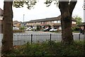
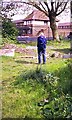
Freemasons Road, Canning Town
From Ashburton Wood.
Image: © David Howard
Taken: 23 Oct 2022
0.03 miles
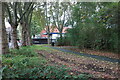
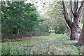
3
Ashburton Wood
A small public area formerly known as Canning Town Woods.
Image: © Robin Webster
Taken: 11 Jun 2011
0.04 miles
5
New housing on Freemasons Rd, from bombsite
Although the site in Newham, from which the photo was taken, is an old bombsite, the surrounding area is all new housing.
Image: © John Rostron
Taken: Unknown
0.06 miles
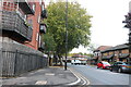
7
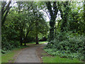
Ashburton Wood
For such a small area of woodland in an urban area, Ashburton Wood has a surprisingly secluded feel. Until 1984 this was the site of a secondary school.
Image: © Stephen McKay
Taken: 26 May 2022
0.06 miles
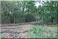
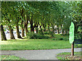
9
Ashburton Wood
This small area of woodland off Freemasons Road was a school from 1893 to 1984 - latterly the Ashburton Mixed Secondary School. The information board gives details of this history and some of the species that can be found here.
Image: © Stephen McKay
Taken: 26 May 2022
0.06 miles
10
Recolonised bombsite near Custom House
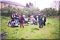
This area was the site of a school that was bombed in the blitz. It has now been recolonized and is mostly woodland with some open areas. Although it is fenced off, it is widely used by local children (and student field visits).
Image: © John Rostron
Taken: Unknown
0.06 miles