IMAGES TAKEN NEAR TO
Wallis Walk, LONDON, E16 2XR
Introduction
This page details the photographs taken nearby to Wallis Walk, E16 2XR by members of the Geograph project.
The Geograph project started in 2005 with the aim of publishing, organising and preserving representative images for every square kilometre of Great Britain, Ireland and the Isle of Man.

There are currently over 7.5m images from over14,400 individuals and you can help contribute to the project by visiting https://www.geograph.org.uk
Image Map
Images are licensed for reuse under creativecommons.org/licenses/by-sa/2.0
Notes
- Clicking on the map will re-center to the selected point.
- The higher the marker number, the further away the image location is from the centre of the postcode.
Image Listing (93 Images Found)
Images are licensed for reuse under creativecommons.org/licenses/by-sa/2.0
Image
Details
Distance
1

Political artwork by the River Thames
On the river wall beside the Capital Ring (walk).
Image: © Oast House Archive
Taken: 2 Dec 2012
0.03 miles
2
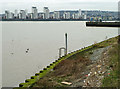
Lower foreshore access ladder
Downstream of the Gallions Point Marina entrance.
Image: © Robin Webster
Taken: 5 Mar 2011
0.04 miles
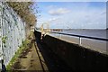
4
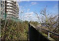
Thames foreshore and riverside path
Downstream of the Gallions Point Marina entrance.
Image: © Robin Webster
Taken: 5 Mar 2011
0.05 miles
6
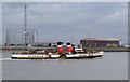
Waverley in Gallions Reach
This is Waverley the last sea going paddle steamer in the world steaming through Gallions Reach on the River Thames. The object grid reference is that of the radio mast in the background. To the right of the gasholder you can see Image it stands in the carpark of a shopping centre.
Image: © Glyn Baker
Taken: 25 Sep 2005
0.07 miles
7
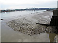
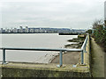
Low tide on Gallions Reach (1)
Looking upstream from the north bank of the Thames, showing the extent of mudflats.
Image: © Stephen Craven
Taken: 21 Aug 2011
0.08 miles
8
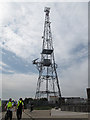
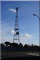
Broadcasting tower, Gallions Reach
There are no signs indicating what company this belongs to or what kind of signal it broadcasts. It certainly includes a radar antenna, probably for river navigation. It is seen from across the Thames in Image
Image: © Stephen Craven
Taken: 21 Aug 2011
0.08 miles
9
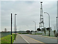
Atlantis Avenue and river bank mast
The mast is for PLA radar.
Image: © Robin Webster
Taken: 5 Mar 2011
0.08 miles