IMAGES TAKEN NEAR TO
Cavendish Square, LONDON, E16 2XN
Introduction
This page details the photographs taken nearby to Cavendish Square, E16 2XN by members of the Geograph project.
The Geograph project started in 2005 with the aim of publishing, organising and preserving representative images for every square kilometre of Great Britain, Ireland and the Isle of Man.

There are currently over 7.5m images from over14,400 individuals and you can help contribute to the project by visiting https://www.geograph.org.uk
Image Map
Images are licensed for reuse under creativecommons.org/licenses/by-sa/2.0
Notes
- Clicking on the map will re-center to the selected point.
- The higher the marker number, the further away the image location is from the centre of the postcode.
Image Listing (117 Images Found)
Images are licensed for reuse under creativecommons.org/licenses/by-sa/2.0
Image
Details
Distance
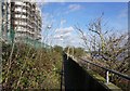
1
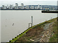
View of the Royal Docks Apartments from the Thames Path #2
Looking north-northwest. A derelict pier can be seen in the foreground.
Image: © Robert Lamb
Taken: 23 Oct 2011
0.06 miles
2
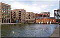
Beckton : Royal Albert Wharf : housing
Housing development at Royal Albert Wharf; architects Maccreanor Lavington
Image: © Jim Osley
Taken: 23 Jul 2020
0.07 miles
3
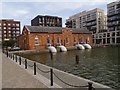
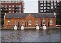
Beckton : Royal Docks Pumping Station
Erected by the Port of London Authority in 1912. Extensively described at this https://openhouselondon.open-city.org.uk/listings/1416
Image: © Jim Osley
Taken: 23 Jul 2020
0.07 miles
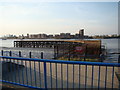
4
Beckton : Royal Docks Pumping Station
Erected by the Port of London Authority in 1912. Extensively described at this https://openhouselondon.open-city.org.uk/listings/1416
Image: © Jim Osley
Taken: 23 Jul 2020
0.07 miles
5

Political artwork by the River Thames
On the river wall beside the Capital Ring (walk).
Image: © Oast House Archive
Taken: 2 Dec 2012
0.08 miles
6
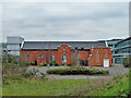
A Docklands survivor
Amid all the redevelopment, this building survives. It is built across the end of an arm off the Albert Dock entrance basin.
Image: © Robin Webster
Taken: 5 Mar 2011
0.09 miles
7
Lower foreshore access ladder
Downstream of the Gallions Point Marina entrance.
Image: © Robin Webster
Taken: 5 Mar 2011
0.09 miles
8
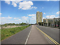
Atlantis Avenue
Construction is going on all around and soon this will be a busy community, but just now it feels quite bleak, even on a nice day like this.
This is on the Capital Ring Path approaching its eastern end.
Image: © Des Blenkinsopp
Taken: 4 May 2016
0.09 miles